
Longreads
70 MIN READ

A thorough look at the origins of Nepal's border claims in the northwest of the country
Introduction
The Anglo-Nepal War, 1814-1816, and known in British circles at the time as the Gorkha War, was fought between two expansionist entities: the East India Company and the forces led by the King of Gorkha. This article brings to light evidence that the East India Company (EIC) made an extensive and very successful intelligence-gathering effort prior to the start of the war and during its early stages. It assesses the results of these efforts and their relevance to the sequence of events which confirmed the settlement of Gorkha’s new western border. I have covered some of this ground in previous articles but over the last few months I have unearthed new material from the East India Company archives which sheds new light on the subject.
In his excellent 2009 book on the war, Britain’s Gurkha War, The Invasion of Nepal, 1814-1816, John Pemble writes:
“The Court of Directors was fully reconciled to the use of force and as early as February 1814 sent a dispatch sanctioning ‘a recourse to arms for the recovery and protection of the rights of the British government.’” (p.50)
The war started on November 1, 1814, and Pemble claims that preparations were being made for a conflict from the middle of June 1814 (p. 85). Pemble’s concept of what constitutes “preparations” is narrowly drawn and his book is also short on detail on the full scope of the information sought and how and why it was obtained.
My main reference is, Papers Respecting the Nepaul War, published in 1824 by the East India Company. It is free to download from multiple web sites.
The PNRW compilation appears to be missing at least one pertinent paper. It is available in Historical Papers Relating to Kumaun 1809-1842, assembled by Dr Banarsi Prasad Saksena in 1956 from papers in the Pre Mutiny Records in the Uttar Pradesh State Records at Lucknow.
This new article complements my other articles on the subject, most notably, The Indian Checkposts, Lipu Lekh and Kalapani and The Gorkha War and its Aftermath. Both can be read in updated form in my book, Maharajas, Emperors, Viceroys, Borders: Nepal’s Relations North and South. (FinePrint, book and ebook available on Amazon.)
I am grateful to The Record for exceptionally reopening the site, so this new article can sit alongside them.
The advocates of Nepal’s Limpiyadhura claim assert that, when the Treaty was first drafted on December 2, 1815, East India Company (EIC) officials had no knowledge of the northern border of Kumaon or the rivers and passes in the area. They are wrong. It is true that the Company did not get a surveyor into the remote and high mountainous areas with a large support team carrying all the cumbersome surveying equipment of the day to do the surveying necessary to fix a new frontier, until May/June 1816. This undertaking was a considerable feat, and we will return later to the initial report of the surveyor, Captain William Spencer Webb, which reached the Governor General in September 1816.
Numerous references in “Papers Respecting the Nepaul War” (PRNW) indicate that the EIC had impressive knowledge of the area prior to the arrival of Webb and his team. Letters from the Governor General to the Board of Directors in the early part of 1815 indicate that EIC agents and officials had been very active in gathering intelligence about Nepal and, since there was never any intention to attack the Gorkha homeland, with a focus on the occupied territories of Garhwal and Kumaon, particularly the latter. This effort increased significantly in the period building up to the outbreak of the war in November 1814. The first 150 pages of PRNW are dominated by a frenzy of letters exchanged between the Governor General and John Adam, the Secretary to the Government, and people who might reasonably be expected to have had meaningful intelligence, about Gorkha’s military strength and about the country’s geography. The letters concentrate on the occupied territories, including routes from the south and to the north into Tibet.
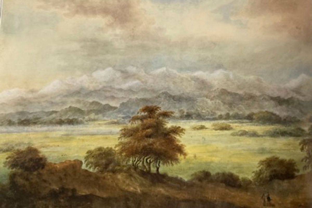
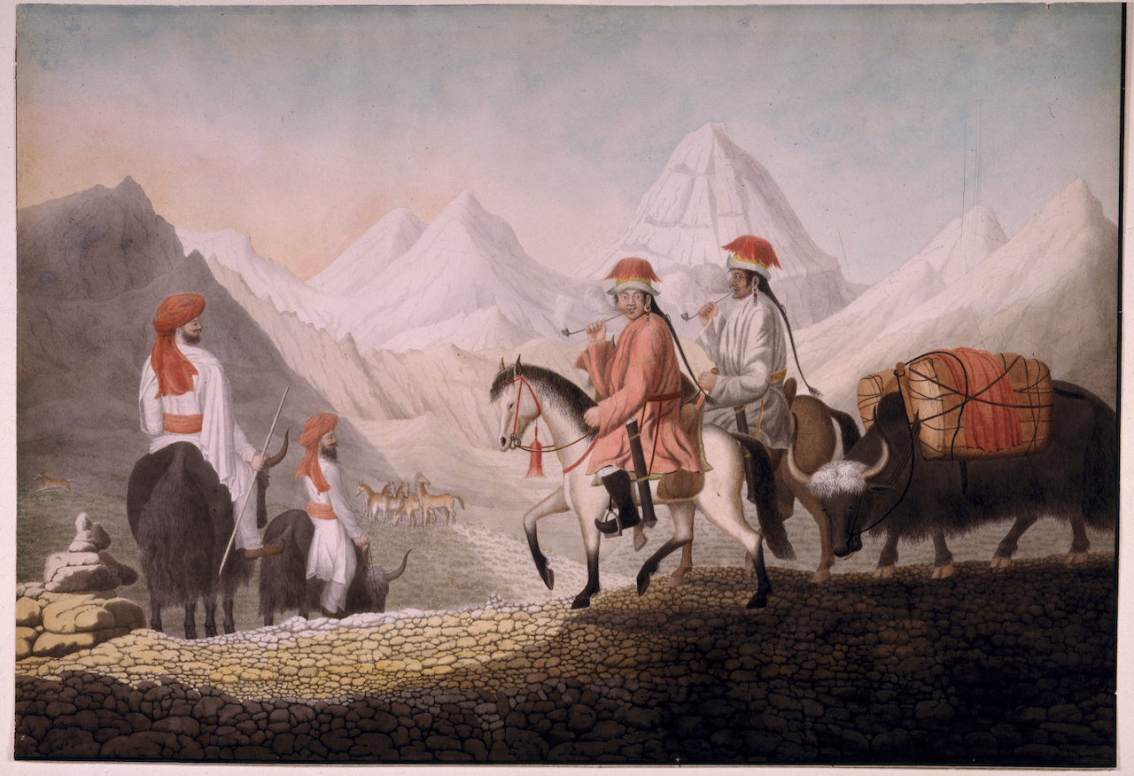
The first clue we have of the Governor General’s knowledge and intentions comes from The Private Journal of the Marquis of Hastings, Volume One, London, 1858, which contains a record of Lord Moira’s thoughts as he got his first clear view of the Himalaya from the roof of the Judge’s House in Moradabad—the view in the image above. It was early in the morning of December 8, 1814, just a few weeks after the start of the war. Hastings’s daughter, Sophia, was with him during the time he recorded his impressions. She compiled The Journal later. He wrote:
December 8th – We went to the Cutcherry, or Sessions House, that from the flat roof of that elevated building, we might see the first rays of the rising sun strike on the summits of the snow ridge. The sight was truly grand. The snow, illuminated by the beams, looked exquisitely brilliant. There was an odd sensation in contemplating a spot on the globe where the foot of man had never trod or was ever likely to be planted. This immense barrier would seem sufficient to limit the concerns of India; yet, at this moment, I am speculating on the trade which may be carried on beyond it, should the present war with the Gurkhas leave us in possession of Kemanon. From that province there are valleys between the hills which afford passage of not much difficulty and greatly frequented into Tartary. The holding of Kemaoon would give to us the exclusive purchase of the shawl wool, to be paid for in cutlery, broad-cloth and grain.
(The Marchioness of Bute’s The Private Journal of the Marquess of Hastings, Volume One, London, 1858, p.251. My highlights.)
These words should not be dismissed lightly. First, we have a clear indication that, at the very start of the war, Kumaon was identified as a key asset that was to be annexed to the Company and that the primary motive for doing so was that it was judged to be the province best suited to facilitate trade with China. Moira was not the sort of man to use phrases like, “not much difficulty” and “greatly frequented” lightly. To write with such confidence, he must, by early December 1814, have acquired specific information about passages into Tibet.
Sections of PRNW bolster this reading.
The gap through the vast Himmaleh mountains at the northern point of Kamaon afford, as we have ascertained, not only a practicable, but a commodious road into Tartary. What extent of trade may be carried on through this passage may now be a matter of loose speculation; probably it will be very considerable.”
(PRNW, pp. 550-551, my highlights.)
Again, the choice of words is instructive. “To ascertain,” says the Oxford English Dictionary (OED), is to find out for certain, make sure of. “Commodious,” the OED tells us, is “Roomy and comfortable. Archaic: convenient.”
There is only one pass in Kumaon that remotely fits that description. This one!
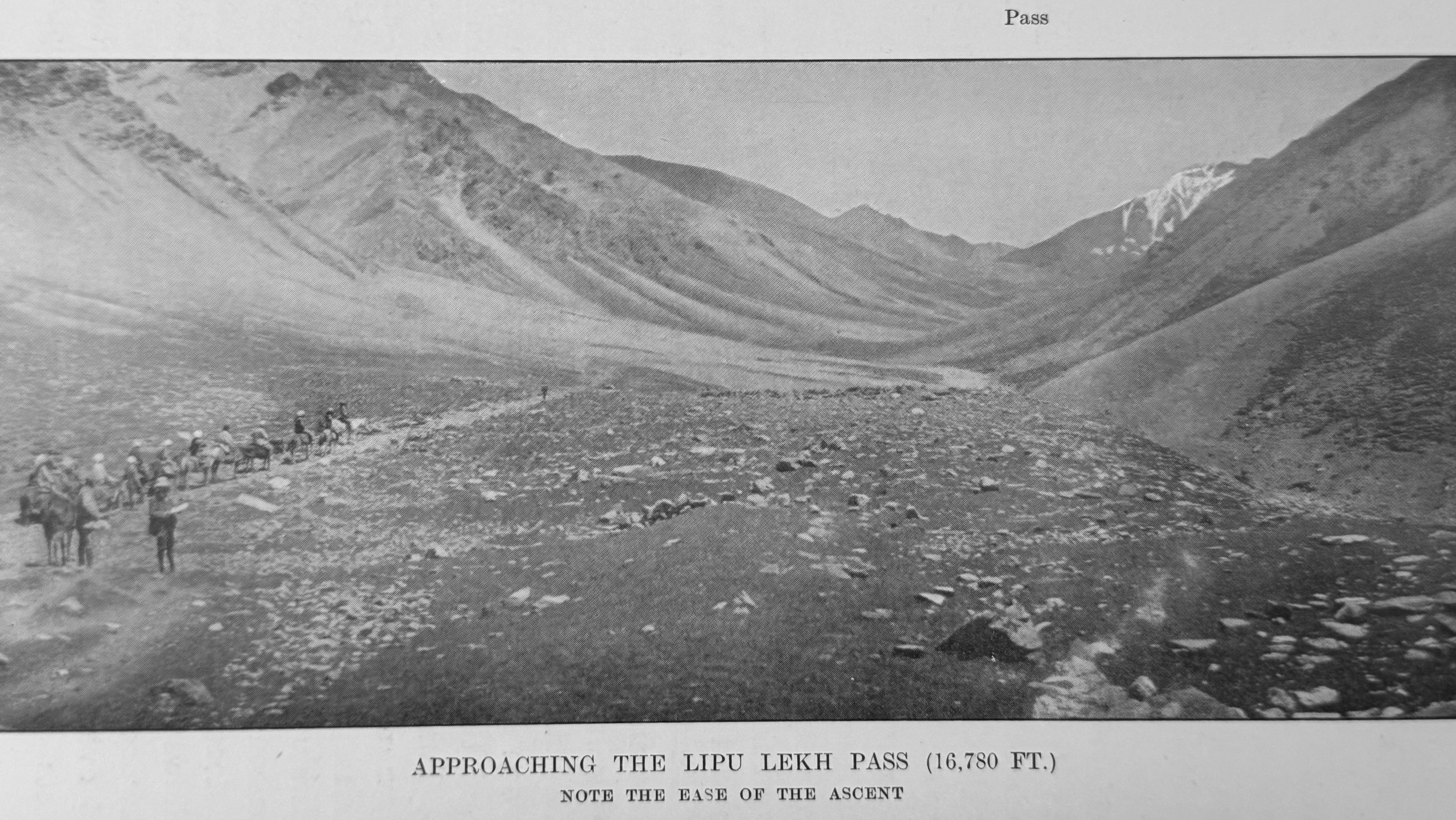
A further example of important information gained on the future frontier is in this “Secret Letter from Lord Moira to the Secret Committee,” dated June 1, 1815.
“Kamaon is likely to prove a very valuable acquisition. The enclosed copy of a report from Mr Gardner will inform you of the estimated value, but there is no doubt that its revenues in every branch will improve. I propose to extend the limit of the province west…. The eastern boundary will be the Kali which rises in the Snowy Mountains and pursues a nearly direct southerly course to the plains, where it assumes the name of the Gogra [sic].
It is not by its direct resources only that I estimate the value of Kamaon. Through that province lies the easiest route across the snowy range of mountains into Chinese Tartary opening to us a communication with that country and the vast regions beyond it and affording a most encouraging prospect to improve commercial resources.”
(PRNW, pp. 565-566, my highlights.)
What I have highlighted is a clear indication that the river being discussed is the one which originates in the area of Lipu Lekh and that the pass under discussion can only be Lipu Lekh. The date of this letter—June 1, 1815—is again an instructive one. How, in a letter of this date to the Secret Committee of the EIC, is this degree of clarity, confidence and certainty possible? The surveyor, Webb, would not reach the area for over another 12 months. The answer must be that it came from an intelligence source or sources in whom Lord Moira and his staff had absolute confidence.
From the beginning of the war, the Company never wavered on the line of the frontier to be established after the last Gorkhas had been removed from Kumaon. Article 5 of an early draft of what became known as the Sugauli Treaty refers to “…the Raja of Nepaul renouncing all claims and pretensions whatsoever over the countries situated to the west of the river Gogra, formerly conquered by the Gorkha army.”
It has this significant comment written alongside it: “The total exclusion of the Goorka influence, power and authority, from the territories west of the Gogra is indispensable. This will leave at our disposal Kamaon association and will quickly circumscribe the resources of the Gorkhas. The Dogra forms a marked boundary, if the limitation should stop there……(PRNW, p. 263)
In the event, the wording in Article 5 of the final draft reflected the same resolve: “The Rajah of Nipal renounces for himself, his heirs, and successors, all claim to or connection with the countries lying to the west of river Kali and engages never to have any concern with those countries or the inhabitants thereof.”
Nor was there ever any doubt in the Company’s mind that the Kali River mentioned in the final draft was the river which flowed down, in an almost directly southerly course, from the area just south of the Lipu Lekh pass. There are numerous other indicators on this point in PRNW. In brief, only a frontier based on the line I have described would achieve what the Governor General considered to be two of the prime objectives of the war: getting a tight, secure, and easily defensible border against future attacks from Gorkha, which was a real fear at the time, and gaining unrestricted access to Lipu Lekh so that the Company could enjoy the great rewards envisaged from trade into Tibet. A frontier running down from Limpiyadhura would fail totally on both counts. That was never going to be allowed to happen.
From where did the intelligence highlighted above originate? What made Lord Moira and the EIC so confident?
This extract from the Himalayan Gazetteer is pertinent:
By the time Lieutenant-Colonel Gardner was fairly established in the hills the greater part of the natives of Kumaon in the service of Nepal had deserted and this loss was quite impossible to supply by new levies. The greatest source of weakness to the Gorkhali cause was the universal disaffection of the people of the country. Nothing could exceed the hatred which the tyranny and exactions of twenty-five years past had created, and no sooner had British forces entered the hills than the inhabitants began to join our camp and bring in supplies of provisions for the troops. The same causes made it easy for us to obtain information regarding every movement of the enemy and give us every facility for obtaining a knowledge of the localities of this country – a knowledge which in mountain warfare such as this, and in the absence of all trustworthy maps, was almost essential to success. (Himalayan Gazetteer, Vol II Part II, Atkinson, p. 654. My highlights.)
This extract from Imperial Gorkha by Mahesh C. Regmi reinforces the point:
…[O]n the basis of the evidence I have presented in these pages, I have no hesitation in arriving at the conclusion that the Gorkhali rule in Kumaon was congenitally marked by such malpractices as ‘extraction, torture, abduction and rape of the wives, daughters and daughter-in-law of the people, collection of unwarranted payments, fines and penalties, forceful appropriation of property, and enslavement,’ and that the people of that province suffered great hardships and misery in all aspects of life.” [Adroit Publishers, 1999.p.134.]
In short, in the occupied territories of Kumaon and Garhwal there was no shortage of people who were very willing to provide the EIC with intelligence that could help end Gorkha rule as speedily as possible.
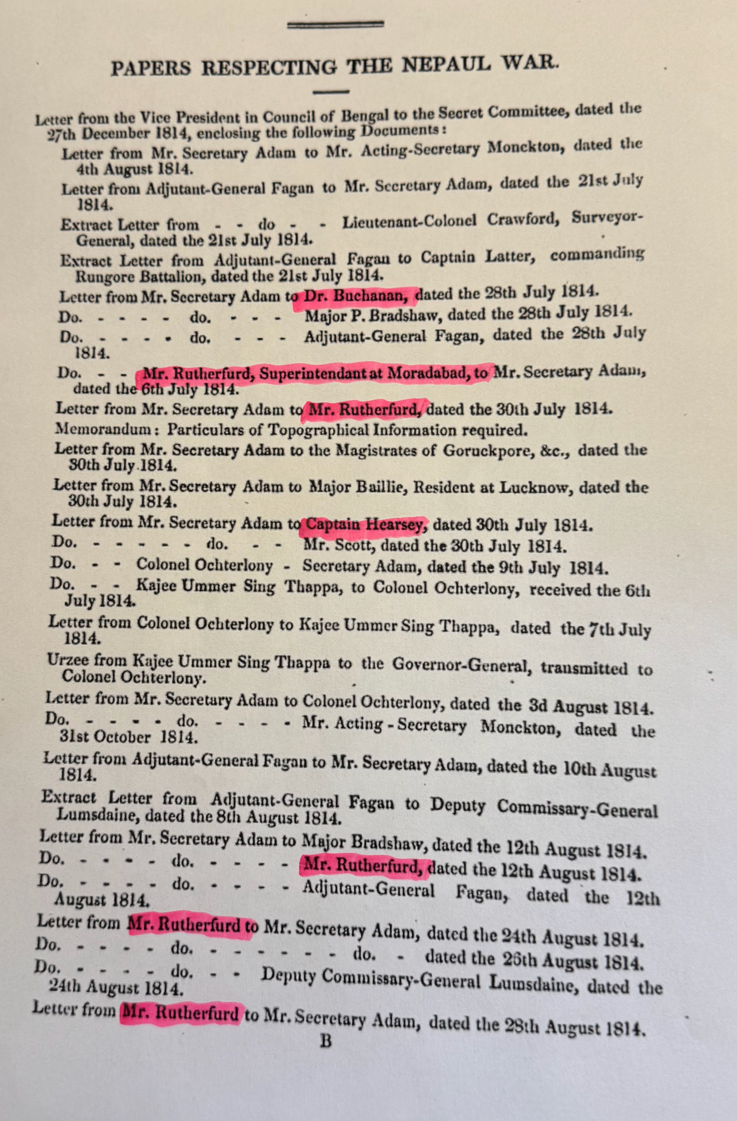
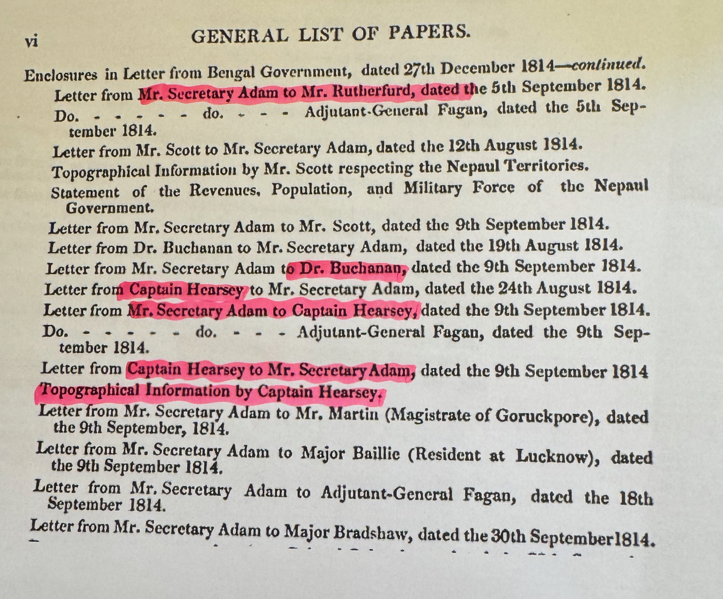
Most of the evidence relevant to the questions posed in this section emerges from a close reading of PRNW, especially its first 200 pages. As noted at the outset, the extracts below, drawn from the opening pages of PRNW, and dated from July to September 1814 —three months before the war began—show that numerous letters were sent to a wide range of individuals asking them to share any information they had about the Gorkhas, and particularly about the occupied territories of Garhwal and Kumaon.
Image 3
Image 4
At the strategic level, Lord Moira consulted the two people he regarded as having the direct experience to give him information on the lie of the land and an informed and considered view on likely Gorkha reactions to the attack being planned. First on the list was William Moorcroft who in 1812 had ventured illegally into Tibet through Gorkha-occupied-Kumaon, accompanied by Captain Hyder Hearsey. The pair were arrested on their return journey and later released. Some of the initial correspondence between the EIC and Moorcroft can be found from Pages 84 to 108 of PRNW. They are worth a close study.
At the strategic level, the most important and influential person consulted was Dr Francis Buchanan Hamilton, a Scottish doctor and botanist who had accompanied Captain Knox to Kathmandu in 1801 and was the most experienced adviser on Gorkha matters available to the Company. His responses and interactions cover many pages of PRNW.
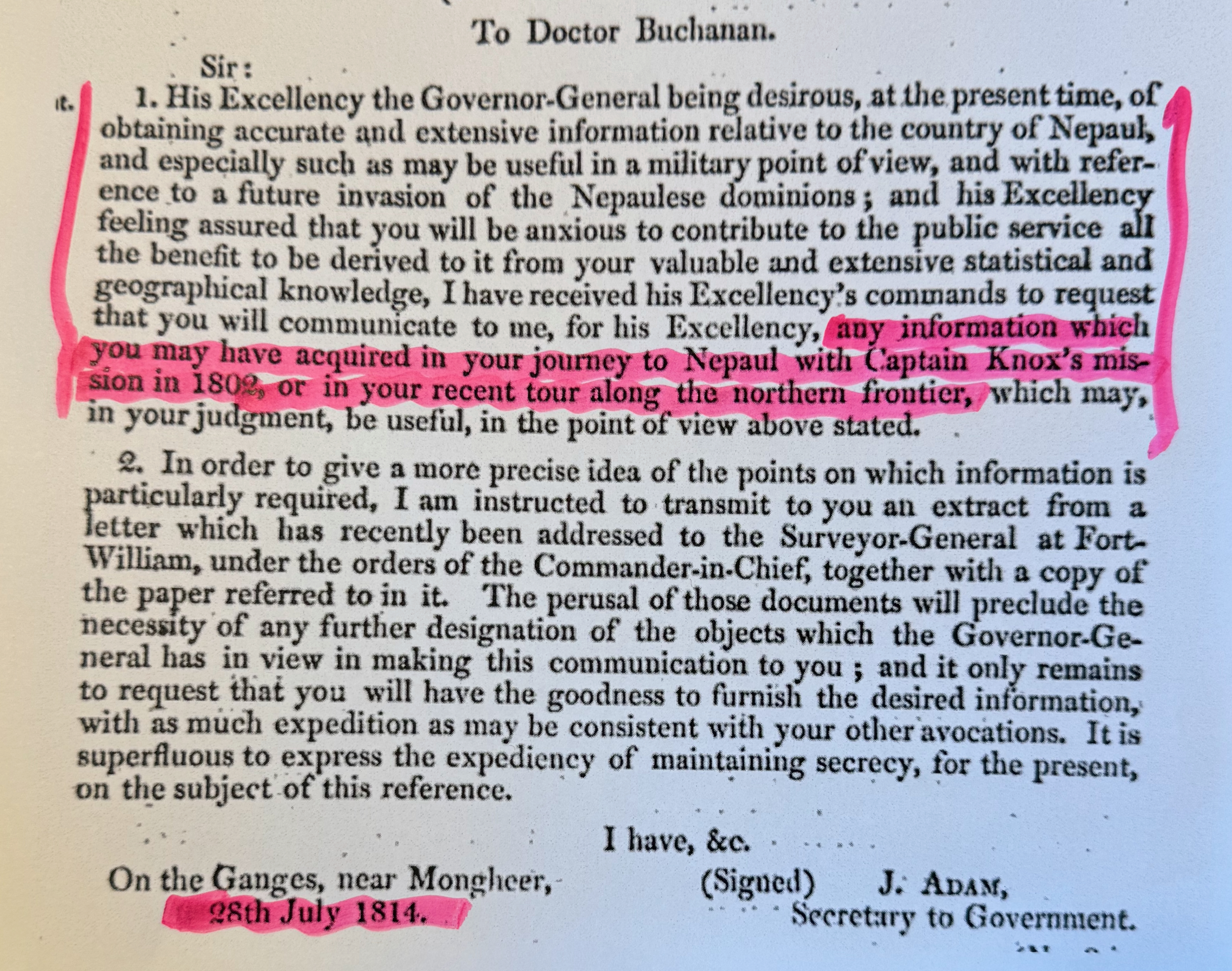
Buchanan’s contribution was also a major factor in the EIC’s decision to open a Sikkim or Eastern Front in the Gorkha War. In 1819, he had published a book, “An Account of the Kingdom of Nepal”. The information that it contained on Sikkim was largely based on a second-hand account from a lama who had fled to Purnea in British India following the Gorkha invasion as well as from “natives of the Company’s territory, who had visited the lower parts of Sikkim”. It includes an outline history of Gorkha attacks on Sikkim from 1782 onwards and subsequent Sikkimese resistance with intermittent assistance from Bhutan and Tibet.
Thomas Rutherford, the Superintendent and A.T., Moradabad
Three characters had much to contribute to what might be described as the vital tactical level of intelligence gathering, starting with Thomas Rutherford, the Superintendent and A.T. Moradabad. (My research for this article soon convinced me that he and his exploits were worth a separate article, but on another day as I have a copy of his personal diary covering the period on its way to me!]) The short description of him in PRNW is misleading in its simplicity. More correctly it should be Thomas Rutherford, Superintendent of the Colipoor Factory and Agent for Timber, Moradabad. Even this hides the fact that he originally went to India in the East India Company’s Medical Service and, as he took on more senior administrative responsibilities, he also had to advance up the East India Company’s medical ladder. He had a keen interest in intelligence and a natural talent for unearthing it. From the EIC’s point of view at the time, he was also in exactly the right place. His area abutted the Gorkha-occupied territory of Kumaon and the southwest part of the Gorkha homeland.
Its strategic importance, and some of Rutherford’s wide responsibilities, are well brought out in this important extract from Himalayan Gazetteer:
Having reached this period of the war we must speak of the events which were happening in Kumaon, and with which we are more particularly concerned. Lord Hastings, in October 1814, had received information which led him to suppose that Bam Sah, the governor of Kumaon, being disgusted with the proceedings of the Thapa party, which at this time exercised the chief authority in Nepal, would not be disinclined to assist the views of the British government and to deliver up his charge into their hands.
Accordingly, early in November, Mr C. T Metcalf, resident at Delhi, received orders to send his second assistant, the Hon’ble E. Gardner of the Bengal Civil Service, to Moradabad, to open a correspondence with Bam Sah in order to ascertain whether the opinion that had been formed of his disaffection to the existing government of Nepal was well founded… In the meantime, Mr Gardner, was instructed that his first duty was to ascertain the disposition of Bam Sah, and it was pointed out to him that this might be accomplished by means of the persons connected with the trading agencies at the foot of the hills. (Read: Rutherford and his contacts) Both Bam Sah and his brother Hastidal, since their exclusion from public affairs, had turned all their attention towards commercial operations and now held a monopoly of the trade passing through Chilkiya and Barmdeo, which brought them a considerable revenue. At the same time, the Company’s factory at Kashipur, under the superintendence of Dr Rutherford as trading agent, kept up a continual connection with the hills, where a large quantity of hemp was raised and prepared, on a system of advances, for the Company’s investment. (Himalayan Gazetteer, Atkinson, Vol II, Part II, pp. 641-642. My highlights.)
(Note: Kashipur has historically been part of Kumaon. It remained under the rule of the Chand kings until it was ceded to the British in 1801, after which it played a major role in the conquest of Kumaon during the Anglo-Nepal war in 1815. After Kumaon was ceded to the British by the Treaty of Sugauli, it became the headquarters of the Terai district in the Kumaon division.)
On the question of who exactly these persons were who were so well “connected,” there seems little doubt that the reference is to Rutherford and his contacts. As will become clear, the claims he makes in Paragraph 2 of this extract are in no way overstated. Rutherford was at the centre of the action described in the excerpts above. In addition to timber, hemp was big business for his factory. Because hemp was a commercial product rather than a military asset, Rutherford could interact deeply with people from all levels of Nepali society without raising the immediate suspicions of the Gurkha governors. Through the Colipoor factory network, Rutherford built a web of contacts that gave him a flawless map of the region’s political fractures and geographical bottlenecks. To secure large quantities of hemp from the hills, Rutherfurd had to negotiate directly with the ruling elite of Kumaon. This gave him direct access to Chautariya Brahma Shah, the Gurkha Governor of Almora, and his influential deputy, Hastidal Shah, Bam Sah’s brother.
Bam Sah , as we will see in Part 2, had a detailed knowledge of the area leading up to Lipu Lekh, including keen awareness that the river which ran down from the area south of it was known locally as the Kali. His personal engagement with the cross-border trade was the likely basis for his detailed knowledge.
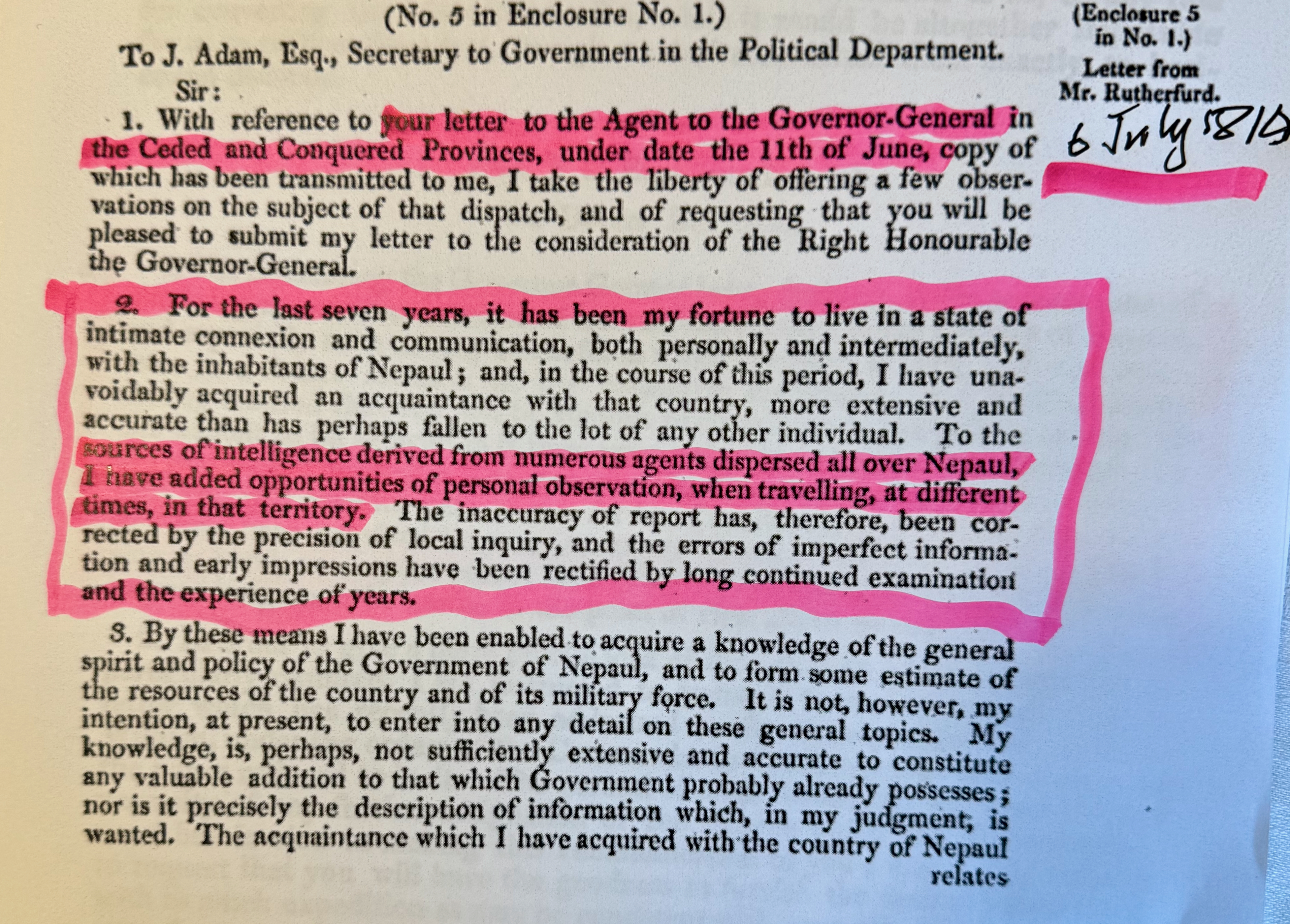
As the extract above shows, unlike other more senior people, Rutherford was not directly contacted by John Adam or a member of his staff. Instead, he was responding to a more general letter sent out on June 11, 1814, inviting all who thought they might have relevant information to pass it on. The many pages devoted to Rutherford’s correspondence in the early part of PRNW demonstrate Rutherford’s belief that he had a great deal of information to offer, including many useful contacts who could offer additional intelligence. His second paragraph must have been calculated to catch the eye of Adam and his staff, promising as it did, the benefit of direct observation: “To the sources of intelligence derived from numerous agents dispersed all over Nepal, I have added opportunities of personal observation, when travelling, at different times, in that territory.”
Later in the letter, he writes:
Personal intimacy has made me acquainted with the character of many of their chiefs, and aided by frequent communication on points relating to their public authority, have served to define the extent of their several jurisdictions, and to exhibit the degree of power and influence which they respectively possess; and various travelling excursions in Nepal, united with a long established commercial intercourse (often made the vehicle of obtaining information regarding the country itself) I have furnished many particulars relating to its topography… (PRNW, p. 8)
And:
I request to be favoured with the orders of His Excellency in Council regarding the disposal of the establishments recalled from the Nepaul territory, in conformity to the instructions conveyed in your letter of the 11th Ultimo. Among these there are many individuals whom it would be highly expedient to retain, on account of the valuable information which, on all occasions, I should be able to procure from them. They are almost naturalised in the hills, and through them I could easily communicate with the zamindars and hemp cultivators, a class of people strongly attached to the interests of the British government. (PNRW, p. 9)
Rutherford received a very speedy and positive response from John Adam in a letter of, July 30, 2014. This listed a request for more information from some specified areas and an invitation for a meeting with the Governor General when circumstances permitted. On Oct 7, 1814, Rutherford sent another dispatch which had attached a list of the zamindars, or landowners, of Kumaon and Doottee with a promise of a list from Garhwal to follow.
In a short note, dated Oct 6, 1814, Rutherford indicated that beyond trade, there was also a strategic imperative to gain detailed knowledge of the layout of Kumaon’s northern border:
“I have the honour to transmit two routes, for the information of His Excellency the Right Honourable the Governor General. With those formally sent, the present complete the information of this description which is now in my possession; but I am in daily expectation of receiving some further details regarding the routes to the Northward, which the Nepalese, when pressed by the advance of an army, might be induced to pursue, in hope of effecting a junction with those from the eastward. The latter, in the event of the successful issue of our operations in that quarter, would most probably retire, in the hopes of meeting with some part of Ummer Sing’s Army…. I expect, in the course of the next 10 days, to be able to present to his Lordship an authentic document from the three provinces of Bhote, Joar, Darma and Danpoor, expressive of their attachment to the British interests, and their readiness to co-operate in any measures for the reduction of the Gorkhalee power.” (PRNW, pp. 108-109)
It is impressive, to say the least, that Rutherford’s contacts and knowledge reached up to the northern Bhotia communities. But there was another man particularly knowledgeable about these and other areas along Kumaon’s northern border, Hyder Jung Hearsey.
Hyder Jung Hearsey
By 1814, Hyder Jung Hearsey had already established a reputation as a formidable Himalayan adventurer. In 1808, with Raper and Webb, he set out to make an accurate survey of the upper reaches of the Ganges. This entailed a passage through Garhwal which the Gorkhas had conquered five years earlier. On their return journey they took a route through Kumaon which the Gorkhas had occupied since 1791. Two days short of the fortress town of Almorah, the capital of the district of Kumaon, they were forced to stop by the Gorkhas and it took a week of delicate negotiations, coupled with promises to send gifts up from the plains, before Bam Sah, the Governor of Kumaon authorised their release.
Hearsey’s report on the expedition showed well-developed surveying skills—although how he acquired them is disputed—and these were again displayed during his next expedition in 1812 when he accompanied William Moorcroft on a journey through Garhwal to western Tibet with the object of visiting Lake Manasarovar. They set off wearing turbans and white linen robes to act like Hindu pilgrims. They travelled into Tibet over the Niti pass, becoming the first Europeans to do so. Their return through Kumaon immediately aroused the suspicions of the Gurkhas. They were eventually arrested and subjected to some rough handling. After sixteen days of captivity, they were set free. Hearsey’s role on the expedition was that of mapmaker: he lacked a theodolite but had a compass and thermometer and kept a survey notebook, and he was assisted by two Indian surveyors. The map he produced from the journey was presented to the EIC’s Court of Directors and earned him a large donation of 6,000 rupees.
Given this wide range of experience, it is no surprise that among the general call for submissions from those with intelligence to offer, Hearsey received this highly personal note from John Adam, dated July 30, 1814, written on behalf of the Governor General himself.
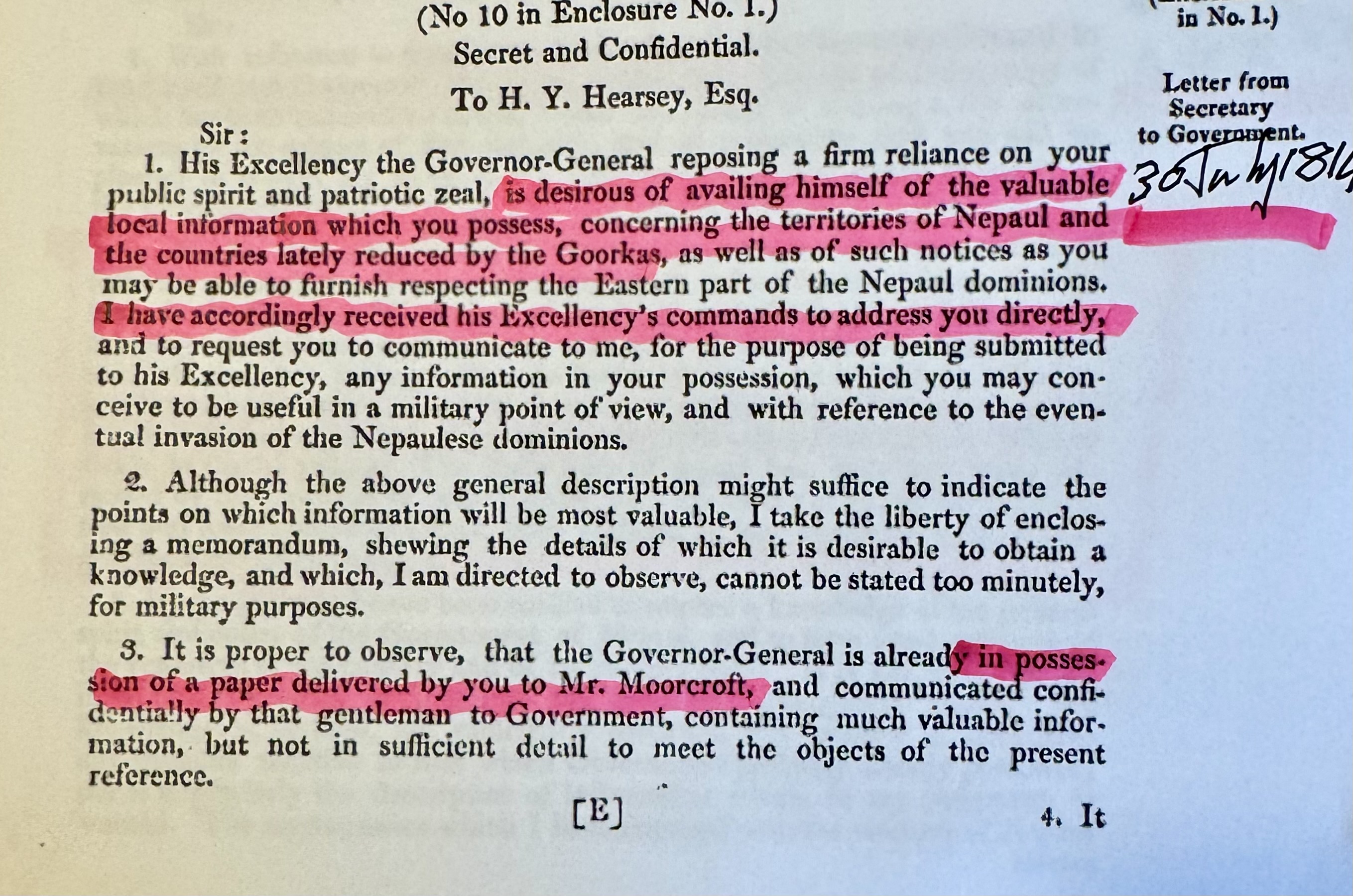
To meet the high expectations placed on him, Hearsey responded voluminously and enthusiastically, including by producing detailed plans for the invasion of Kumaon, which included how he and his brother-in-law, William Linnaeus Gardner, could raise their own levies of irregulars to take part in it. This article will confine itself to giving some extracts from his various responses, starting with his letter dated, August 24, 1814:
2. …I will also furnish you with a sketch of all the passes into the mountains, from the river Sutleje to the Gogra, with the country on this side, and places leading to, on the opposite side of the mountains. I cannot promise the whole of the positions being exactly fixed, but it will serve all military purposes.
4. The knowledge I possess of the interior of the Gorkha-conquered countries extends particularly to the kingdoms of Gurhwall and Kemaon. These I have crossed in two or three lines and have much local information of. The information I have received comes from the best authority. Hurruck dos Jotshee (the Earl of Warwick of these two kingdoms, the Rajah of which he has throned and dethroned more than once. This man is a perfect instrument whose name the Gorkhas dread…) (PRNW, pp.47-48.)
This character appears as Harak Deva Joshi in John Pemble’s book, Britain’s Gurkha War: The Invasion of Nepal 1814-1816, where he is described as:
A one-time supporter of the Chand kings, he encouraged the Gurkhas to invade Kumaon but fled to Garhwal when they turned against him. From Garhwal he plotted to build an anti-Gorkha coalition and found a ready listener when the British started to prepare to invade the hills in 1814. His anti Gorkha activities brought him into a coalition with Hyder Hearsey. Joshi was the man most obviously qualified to raise a local rebellion in Kumaon. He had great influence over many of the exiled hill rajas. Though fully aware of the government's intention to annex Kumaon, Joshi agreed to exert all his influence in favour of the British invasion.
As a source of information on Kumaon, it would be hard to imagine anyone better. In the same letter, Hearsey continues:
Hurruck dos Jotshee’s information will be valuable, correct and direct, and by means of his son, or other agent, he may have at Nepal(sic), a perfect knowledge may be derived of the interior possessions of the Goorkas to the eastward, their force, forts, passes, and means of carrying on warfare. He will be able to furnish proper men for guides.
Hearsey also gives his assessment of the Gorkha Army. He is scathing about its leadership but on the quality of the soldiers he writes some words of significant historical interest:
…..[T]hey are hardy, endure privations, and are very obedient, have not much of the distinction of caste, and are a neutral kind of Hindoo, eating in messes almost everything they meet with except beef. Under our government and officers they would make excellent soldiers, and numbers would, in the event of a rupture, join our standards for the sake of six rupees per month, and form a proper core of hill rangers.
What is historically significant is that these words are written 18 months ahead of those who are generally quoted as the people who first advocated such recruitment using the same reasoning.
He finishes this letter by saying that “if the country were given back to the former rajhas, a great flow of commerce would take place, highly beneficial to Great Britain by the Bootunt passes of Neetee, Mana, Juraar and Tucklakote, find their way into Tartary and even China.” Tucklakote is Taklakot and clearly relates to the Lipu Lekh pass.
Hearsey follows this letter up with a short one dated, Sep 9, 1814:
I hope the enclosed will prove satisfactory. I have taken the liberty to send a rough statement, which will give some ideas of the kind of commissariat that will be required, of which his lordship must be the best judge, as it must depend upon the number of troops brought into action. The sketch map includes the whole face of the mountains skirting the plains extending from the Sutlej to the Sarda. I have compressed the whole into one sheet on a scale of eight geographical miles to an inch. (PRNW, p. 51.)
This letter has a 10-page attachment which ends with:
The man whom I recommend strongly for organising all the plans is Hurruck Dos Jotshee(the Earl of Warwick of the mountains, and the only patriot existing) His name is a terror to the Nepalese and his information is superior to any man's. He is now resided at Hurdwar incog. This man has at his control the following Rajahs: Sunsar Chund, Ram Sing, Kurreen Purkaush, and the Kylooneeas and Sermoreeas family, besides the Sirrinuggur Rajha. (PRNW.p.59.)
John Adam responded to this 9 Sep 1814 letter, with its many attachments, in a very positive way as this short extract indicates: “…the facts and opinions contained in the communication above acknowledged, have formed a useful accession to the knowledge acquired by the Governor-General on the points to which they relate.”
The letter also led to GH Fagan, the Adjutant General, sending a letter, dated Nov 12, 1814, which included these lines: “Captain Hearsey’s statement of the number of Kamaoness which is supposed to be in the Gorkha service, and the desire he attributes to them of entering ours, will attract the notice of the Governor-General. It should, no doubt, be highly expedient to encourage such a disposition, if it really exists, and facilitate the means of its being gratified.”
Hearsey was not a man to delay. On Nov 3, 1814, he sent a lengthy letter to the Adjutant General with this opening paragraph: “I have the honour to acknowledge the receipt of your letter, dated 30th ultimo , and have the pleasure to forward to you a plan for the formation of a Nujeeb Battalion, consisting of one thousand, twelve hundred, or fifteen hundred men, for the consideration and sanction of the Right Honourable the Commander-in-chief.”
The five pages of text which followed contains a host of impressive detail of what had to be provided to get this battalion ready for service within a few months of the Governor-General giving final approval.
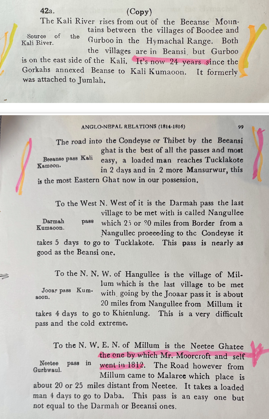
Finally, on Hearsey, we have the last paragraph in the above image, taken from the papers assembled by Dr Banarsi Prasad Saksena from papers in the Pre Mutiny Records (PMR) in the Uttar Pradesh State Records at Lucknow. In the papers, the insertion appears at the bottom of page 98 immediately after a letter dated May 14, 1815, from W.L. Gardner to Colonel Nicolls, Commanding in Kumaoon. Two days later a letter from Colonel Nicolls to C.M. Ricketts, reported that Gardner had personally just escorted Bam Sah and his entourage to the east side of the Kali river. The opening paragraph read:
I have the honour to transmit herewith, by express, a copy of a dispatch just received from Lieutenant Colonel Gardner, announcing that the Chautra, his army and effects (with a very small exception) had crossed the Kali on the evening of the 14th instant, according to the terms of the convention concluded with that Chief and the other Goorka Sirdars on the 27th Ultimo.
No date or names are specifically given but we know from the final paragraph that the writer is the redoubtable Hyder Jung Hearsey, from the reference to him and Moorcroft relating to 1812. The year is clearly 1815, from the reference to the Gurkha annexation of “Beanse to Kali Kumaoon” 24 years earlier. The precise date is not so important but the words in the second paragraph are a good pointer that it was written in the third quarter of 1815: “The road into Condeyse or Thibet by the Beeansi ghat is the best of all the passes and most easy, a loaded man reaches Tucklakote in 2 days and in 2 more Mansurwur, this is the most Eastern Ghat now in our possession.””
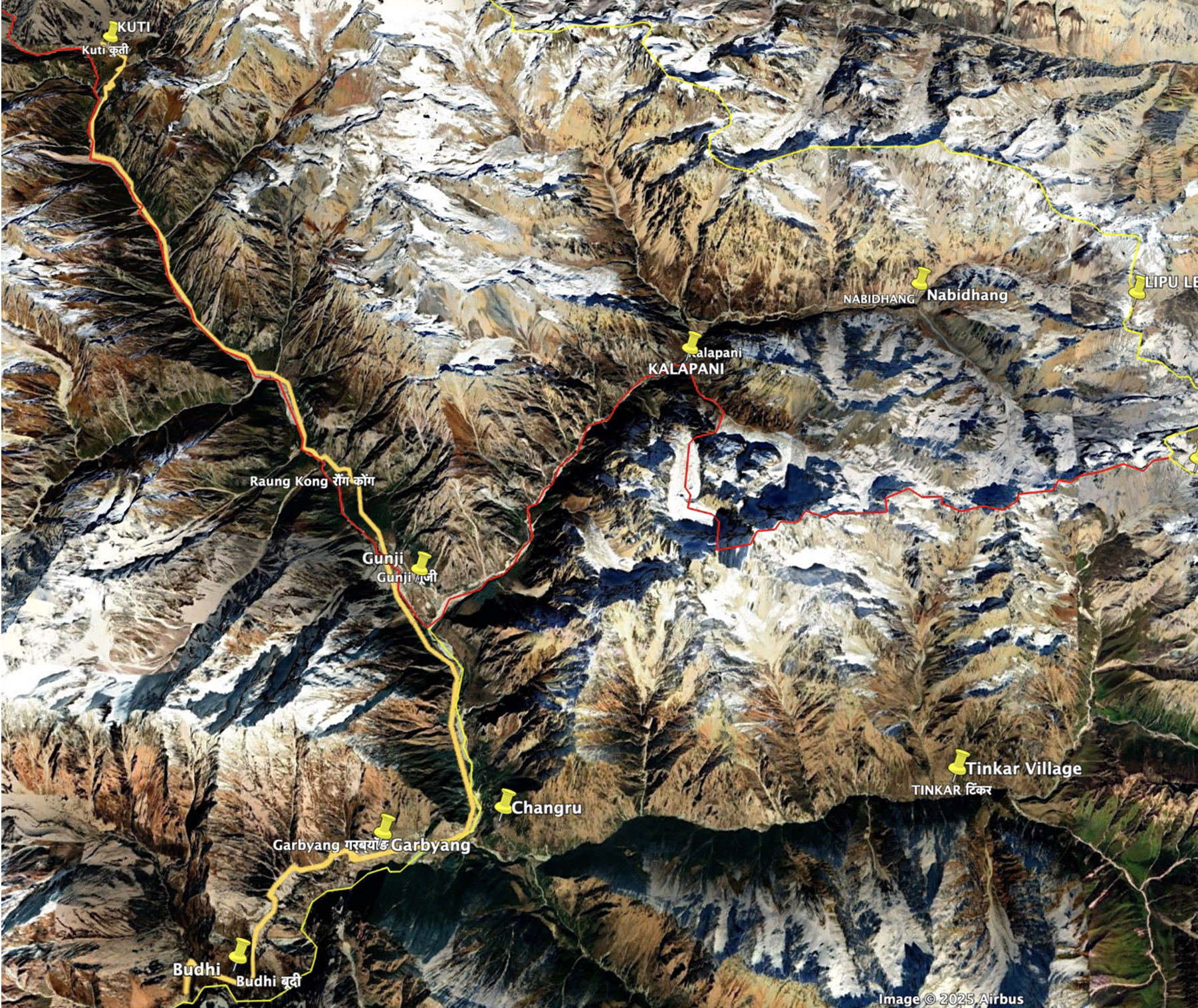
It is clear from references earlier in this article that the EIC knew much earlier than mid 1815 that Lipu Lekh was the “best’ and ‘easiest” of the passes into Tibet. What is interesting in this note from Hearsey is that from mid 1815 the East India Company knew that the Byansi community was split by the river flowing down from the area of Lipu Lekh with at least one of their villages being located on the east side of the Kali: The Kali river rises from out of the Beeanse Mountains between the village of BOODEE and GURBOO in the Hymachal Range. Both the villages are in Beansi but GURBOO is on the East side of the Kali
Looking at the Google Earth image below, it would appear that Hearsey mixed up Garbyang and Changru: in short, it is Changru which is on the east side of the river.
William Fraser
The last character to feature is William Fraser, another formidable EIC officer. He was appointed political agent, prior to the war, and these lines from Pemble describe him well:
Fraser, a young laird of Inverness, was garrulous, opinionated and highly extrovert. He was destined to die at an assassin’s hand, as unconventionally as he had lived. Although he had chosen to make his career in the Company’s civil service, temperamentally he belonged to its army. An intimate friend of Jim Skinner, he loved to pose as a military expert…. Irresistibly attracted to any affray, he had accompanied Gillespie to the assault of Kalanga on 31 October and received a serious arrow wound in the neck.”
He aspired to be the Company’s first Resident in Kathmandu, but it does not require a lot of imagination to see why the Governor General selected Edward Gardner, a very different character, for the appointment. During the Gorkha war, Fraser was consulted for his general knowledge of the conquered Gorkha territories and particularly on the area of Garhwal. These extracts are from a nine-page letter he wrote to John Adam, dated Oct 20, 1814:
The information which I have received from Hurruk Deo Jotshee, and from a person called, Toolaram, formerly in the service of the Sreenuggur family, leads me to imagine that the motive with which the Governor General has considered the expediency of retaining a part of the whole of the country of Garhwal, or the valley of Sreenuggar, and to annex it to the British possession, would in general be more applicable to the province or district of Kamaon. I understand that the trade and intercourse through that country into Bootan and the western regions of the Chinese empire is more regular, extensive, and continued, than that which passes by the route of Sreenuggur; that the roads through the hills are more accessible, that they remain a longer time unobstructed and that the articles imported are more valuable and the distance from the trading stations in the one country to those in the other less considerable; that the people are more civilised and the physical difficulties more easily surmounted. (PRNW, p.235, emphasis mine)
4. You will be pleased to observe, that as yet the extent of my knowledge on this point must be very circumscribed. Few people are found in Hurdwar acquainted with the trade; but a pretty strong proof of the truth of the supposition is that the large towns in the districts of Moradabad and Bareilly, which are situated on the skirts of forests covering the plains for some distance and sloping down from the hills of Kumaon, are the principal emporiums, and that several merchants of note are found in the capital of Kumaon, Almora, and in the Kumaon country; whereas the intercourse with Srinagar is confined chiefly to the frontiers, until and to an interchange mutually beneficial of corn for salt. The principal marts are held in Kumaon, and a thoroughfare is established which does not exist in any part of Garhwal. It is true that the most practicable pass in the Snowy Mountains lies within the confines of Garhwal; But from thence the roads strike off towards Kumaon, running across that district to Rohilcund. (PRNW, p. 236 emphasis mine)
Para 4…..From that pass the route to Srinagar, by Badreenath, is difficult and impracticable to cattle; Whereas the waves passing through Kumaon from Nette Mana gaut are frequented and traversed by the small breed of Bootan horses……
Para7…. In addition to these, and many similar reasons, which might be brought forward to strengthen the proposition that Kumaon is more eligible apparently than Garhwal, as the connecting province between India and the countries to the east…. (PRNW, p.236, emphasis mine)
Para 11. The Sixth paragraph of your letter relates to Harruck Deo Jotshee. I have found him such as he is mentioned to be in the reports received by government. Although exceedingly depressed by misfortune and reduced by penury, he still possesses an active, energetic and enterprising mind. His forefathers the hereditary landlords of Kumon, established the predecessors of the last ruling family……….. Harruck Deo expresses himself plainly and candidly on the points alluded to in the seventh, eighth and ninth paragraphs of your letter. (PRNW, p 237, emphasis mine)
In “Notes” attached to this letter, these extracts appear:
(Para 2) There are four passes through the Snowy Mountains leading out of the Garhwal district. The Lama Neete pass, leading from the Rofwaeen pergunna; Nitte Mana pass, leading from Budrenath; the Ghura Neete pass, also leading from Budrenath and the Deemar purgunnah; the Birgau pass, leading from Pergunnah Pyn Kundah. The Lama Nittee and Bhirgau pass continue open for two months in the year; the Nittee Mana pass and Ghura Nittee for six months. These are the principal and most frequented passes in the two districts of Kumaon and Gurhwal, and through them comes most of the Borax, the chiefly valuable article of importation from Bootan. (PRNW, p.242, emphasis mine)
Para 3. The principal return route from Bootan, or for imports from that country, is by the Nittee Mana and Ghura Nittee passes to Budrenath, and thence directly across the district of Kumaon to Casheepoor in Rohileund. (PRNW, p.242, emphasis mine)
Para4. There is no considerable Mart or Fair in Garhwal district. A small quantity of articles is brought through Sreenagaur by the return of pilgrims, who proceed from Hurdwar fair to Budrenath and meet their the Bootanese merchants. (PRNW, p.242, emphasis mine)
Para 5. The trade is chiefly carried on by the inhabitants of this and that side of the snowy range: those on this side employing goats and sheep as a means of carriage: those on the other side, small horses. (PRNW,p.242, emphasis mine)
Para 7 The distance from Budrenath to the Nitee Mana pass is a short day's journey; that of Ghuri Nittee further. (PRNW, p 242, emphasis mine)
Para 10 Although the Nittee Mana and Ghura Nittee pass are situated within the province of Garhwal, the thoroughfare of trade lies through Kumaon. (PRNW, p.242, emphasis mine)
Also attached is a “Memorandum relating to Kumaon” containing these extracts:
Para 16. In the snowy mountains to the northeast of Kumaon, there are only two frequented passes called Joar to the northwest and to the southeast. They are less practicable than the two great passes from the district of Garhwal, but are more used in traffic. (PRNW, p.246, emphasis mine)Para 17. There are two principal marts in the Kumaon districts for the produce of Bootan. One, that is Bagheeshur which is frequented two or three times a year in Magh, in the days of Sankranti, in Palguna on the fourteenth day and in Jyaishshta on the sixteenth day of the month. The other, at Chylatee, which is attended once in the year in the month of Chaitra on the day of the full moon. This fair lasts ten days. There are none such held in Garhwal. From these places merchandise is sent to Casheepoor, Moradabad and Bareilly and all the towns in the plains of Rohilcund. (PRNW, p. 246, emphasis mine)
Para 18. There is no question on the advantages possessed by Kumaon over Garhwal, as a connecting district between India and Tartary, Bootan and to China, as to the easiness of passage and convenience of intercourse. (PRNW, p.246, emphasis mine)
Para 20 The preceding information was obtained from Hurruk Deo, who in political matters must be considered an interested person. The historical and statistical facts may be relied on. (PRNW, p.246, emphasis mine)
Summary
In 1814, Governor-General Lord Moira wrote at various points about the aims of the war—that the EIC was seeking to gain access to control of trade into Tibet and beyond and that, to do this, it needed control over Lipu Lekh. This overview provides irrefutable evidence that when he did so, he was drawing on a massive and intensive intelligence effort which drew on a range of high-quality sources who were solidly connected with reliable informants. The focus of this effort included the northern areas of the occupied territories of Kumaon and Garhwal, and the routes which ran through them to the high passes which led into Tibet. This work enabled the Company to go firm at an early stage of the war on the most advantageous new frontier that had to be imposed on Gorkha when the war ended. The speculation on the possibility of gaining a monopoly over the ‘shawl-wool’ trade was to prove hopelessly illusory, but Moira and his team were, from a very early stage, remarkably sound and accurate on the solid facts of geography and, most notably so, when it came to identifying the Kali River mentioned in the Treaty as the stream which flowed down from the area of Lipu Lekh. As we will soon see, the basis of the claim that came from the Nepal Durbar in early 1817 for handing back the villages of Changru and Tinkar show beyond any doubt that Nepal shared the same view on the origin of the Kali mentioned in the Treaty.
What I have highlighted should dispel any notions that the Company fought the war in an information or intelligence vacuum. One key example is the speed and clarity with which the EIC articulated what it saw as the line of its future border with Gorkha, as exemplified by this comment, dated 27 Dec 1814, just seven weeks after the start of the war, taken from an early draft of what became known as the Treaty of Sugauli. Article 5 of the draft refers to the Raja of Nepaul renouncing all claims and pretensions whatsoever over the countries situated to the west of the river Gogra, formerly conquered by the Gorkha army. It has this comment written alongside it:
“The total exclusion of the Goorka influence, power and authority, from the territories west of the Gogra is indispensable. This will leave at our disposal Kamaon, and will greatly circumscribe the resources of the Goorkas. The Gogra forms a marked boundary, if the limitation should stop there…..” (PRNW, p. 263)
The Treaty of Sugauli which marked the end of the war was signed on December 2, 1815, and ratified by both parties on March 4, 1816. Article I of the Treaty stated: “There shall be perpetual peace and friendship between the Honourable East India Company and the Rajah of Nepal.”
Judging from reactions at the time, Article 8 was the most difficult one for Gorkha to accept as it led to a permanent British Resident in Kathmandu. Both before and after the signing of the Treaty, Gorkha appealed to the Chinese Emperor to ask the British to remove this Article from the Treaty. In his article, “China and the Anglo-Nepal War: 1814-1816,” Leo E. Rose records that when Nepali officers arrived at a meeting in Tibet, to which they had been summoned, the Chinese greeted them with an aggressive outburst: “You and the Feringhi have concluded a gha (treaty). Both letters agree. When you already have a settlement why do you make more trouble? You must live in peace with others”. Rose cites a letter from Ranbir Thapa to Bhimsen Thapa, dated September 7, 1817.
In the next paragraph, Rose quotes the Chinese Commander as saying to Dalbhunjun Pande, “The English have written to us that they sent their resident with your consent. Therefore, at what have you to complain?” Research I did for my article, “The Battle for the Ear of the Emperor,” revealed that the Chinese did write to the Governor General on the subject but in such a half-hearted way that the British were confident enough to ignore the request. The Resident stayed, and for a long time.
However, in early 1817 word reached the Governor-General from the Resident in Kathmandu that Nepal had another concern, this time based on Article 5 of the Treaty which stated, “The Rajah of Nipal renounces for himself, his heirs, and successors, all claim to or connection with the countries lying to the west of river Kali and engages never to have any concern with those countries or the inhabitants thereof”. The extract below from the Himalayan Gazetteer gives an excellent summary of what was requested, the response and its consequences. It bears a close read. Of note is the fact that in 1817 Nepal made two separate and distinct claims: each time for two named villages but based on totally different grounds. These claims should not be conflated though, highly misleadingly, they often are. The differences in time and rationale are very clearly delineated in this short extract from Himalayan Gazetteer, Vol II, Part II, pp. 679-680.
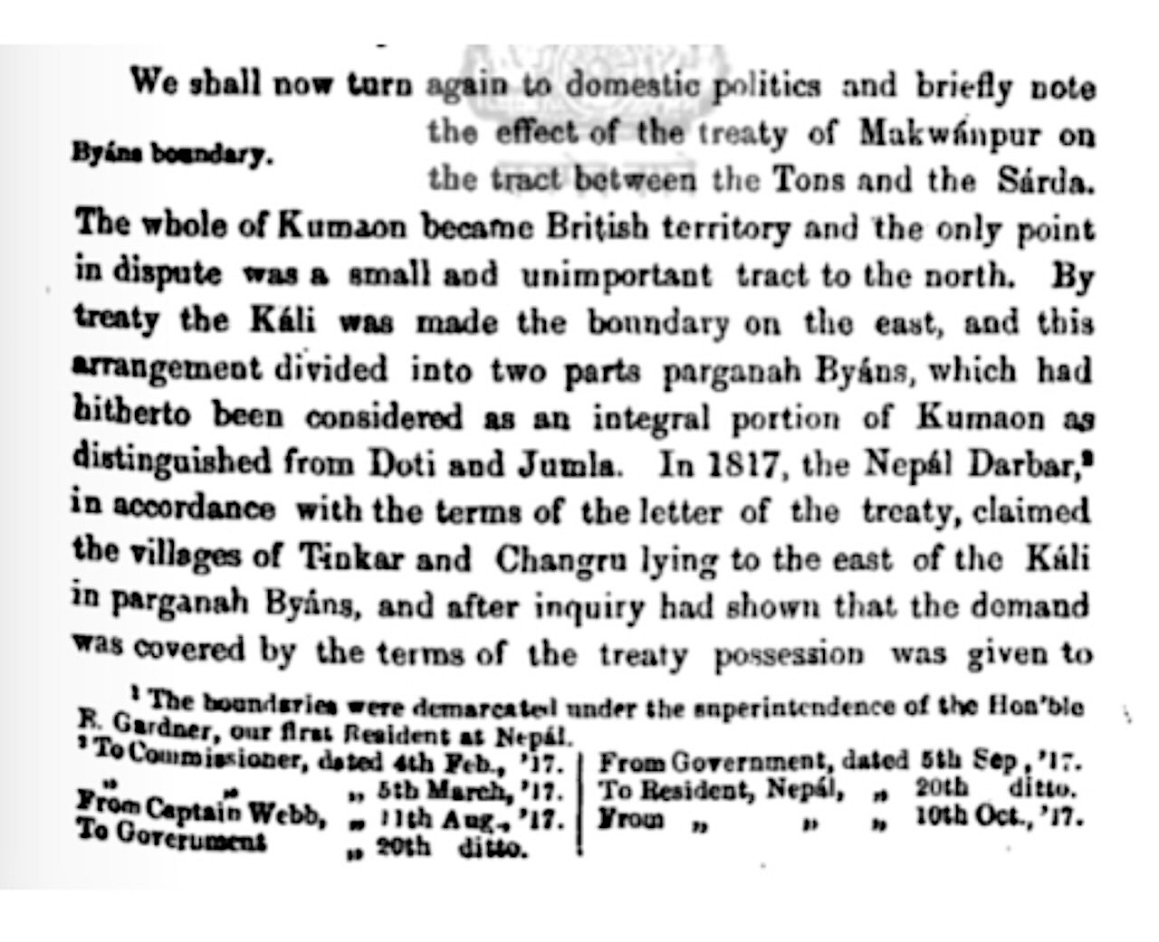
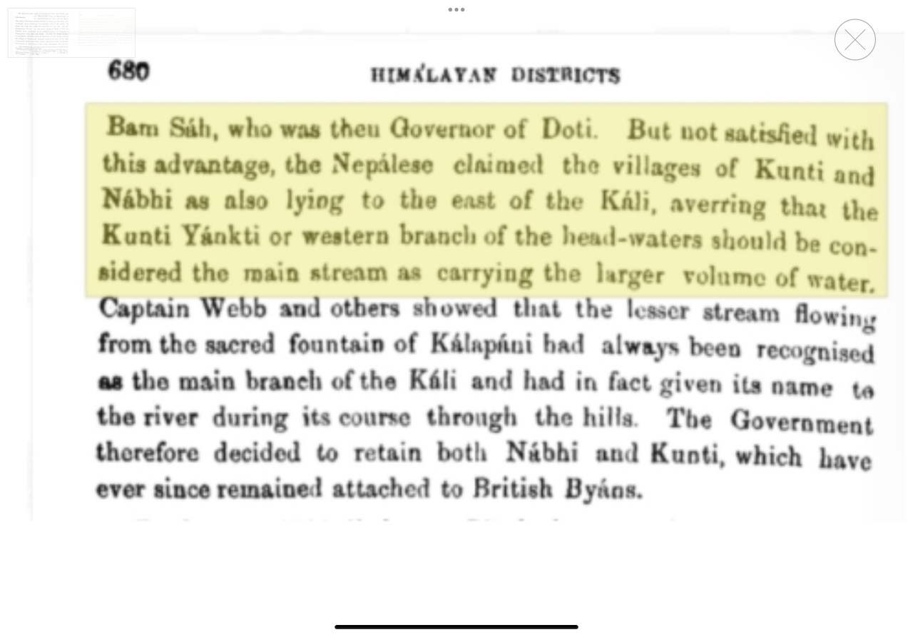
The first claim was made in early January 1817 and was based on Nepal correctly asserting that, “by treaty the Kali was made the boundary to the east and this divided into two parts of parganah Byans.” Therefore, Nepal argued, “in accordance with the terms of the letter of the treaty…. the villages of Tinkar and Changru, lying to the east of the Kali in parganah Byans” should both be handed back to Nepal. This claim was acceded to. So, the basis of Nepal’s claim could hardly be clearer in showing that Bam Sah and the Nepal government were fully aware, and accepted that, the Treaty reference to the Kali as the boundary, meant the river which flows down from the area of Lipu Lekh. This simple fact cannot be fudged, nor hidden.
RS Tolia’s book British Kumaon–Garhwal, An Administrative History of a Non-Regulation Hill Province is littered with references to contemporaneous letters and documents from the Pre-Mutiny Records of the National Archives of India. He records that when the zamindars of Byanse were informed of the decision to separate Changru and Tinkar from the rest of the Byansi villages, “the zamindars pleaded, through a petition, that the remaining six villages, viz., Budhi, Garbyang, Nabi, Rongkali, Gunji and Kuti were entirely dependent on the agricultural production of these two villages and they would be forced to desert these villages in the event of their transfer. They even suggested that they would be forced to divert their entire trade to the Doti marts in Nepal.” (p. 81) Despite these strong appeals and representations, the decision to hand back the two villages stood.
I researched and wrote about this area of debate previously. Returning to the subject recently, I reread the letter from John Adam to Edward Gardner, the Resident in Kathmandu, dated February 4, 1817, which is the first reference given in the Atkinson extract. Here is the opening paragraph:
I am directed to acknowledge the receipt of your dispatch of the 12th Ultimos, enclosing of your letter to the resident at Lucknow, respecting a spot on the left bank of the Dogra which Chautrea Bum Sah is anxious, should be left within the Nepalese Frontier, and responding for the considerations and order of Government a claim prepared by the Chautrea to that portion of Pergunnah Beasse (Byas) which lies East of the Kali and which is at present in the occupation of the British government, as an appendage of the province of Kumaoon.
Earlier I had failed to spot what was now blindingly obvious to me. The trail started, not with the first letter, dated “4th Feb, ’17.” listed as the first reference given in the Himalayan Gazetteer from Edward Gardner to John Adam but in an earlier letter dated, 12 January 1817. which Gardner had sent to Adam. Thus started the search for what was clearly the seminal letter of this entire correspondence. After much frustration, and with the help of friends in the Bodleian Library and in the British Library. It was found among the last 10 pages of a file labelled with this description of its contents:
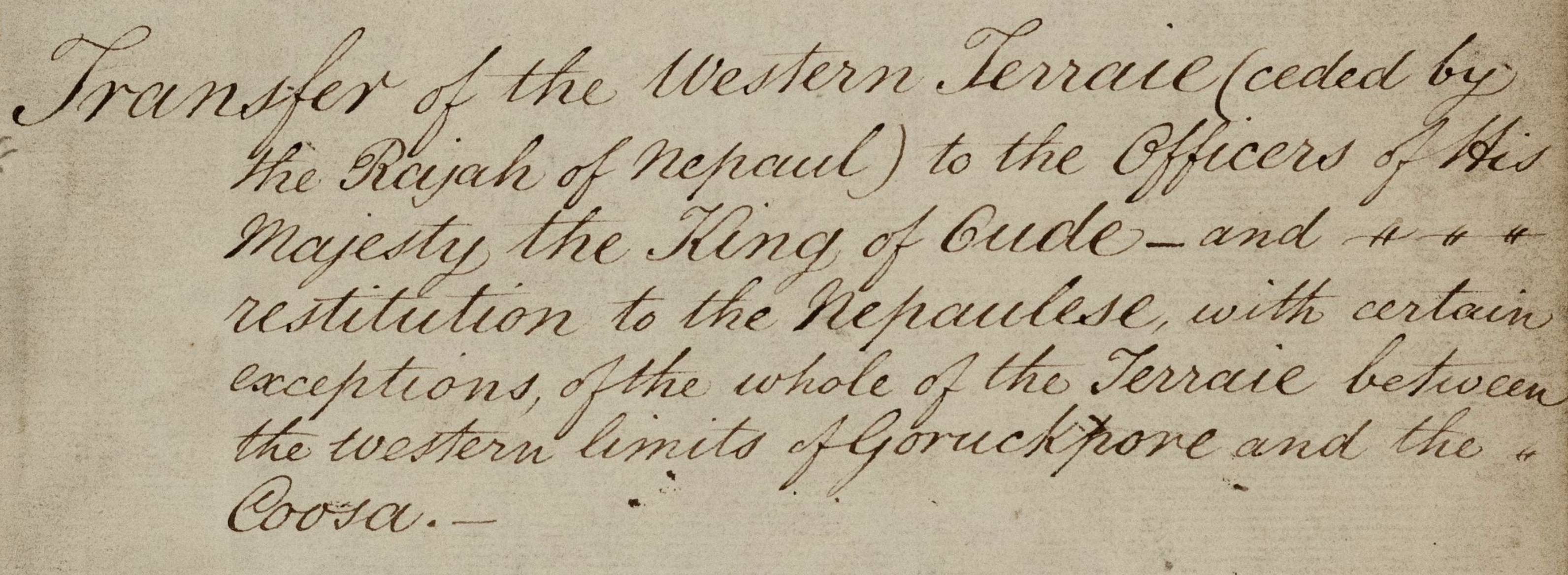
The images which follow are of the opening lines of Gardner’s letter to John Adam, dated January 12, 1817. A full transcription of the entire letter follows.
Images 15 and 16 These two extracts show the opening lines of Gardner’s letter to John Adam, dated 12 January 1817. IOR/F/4/686/1, pp 341-345
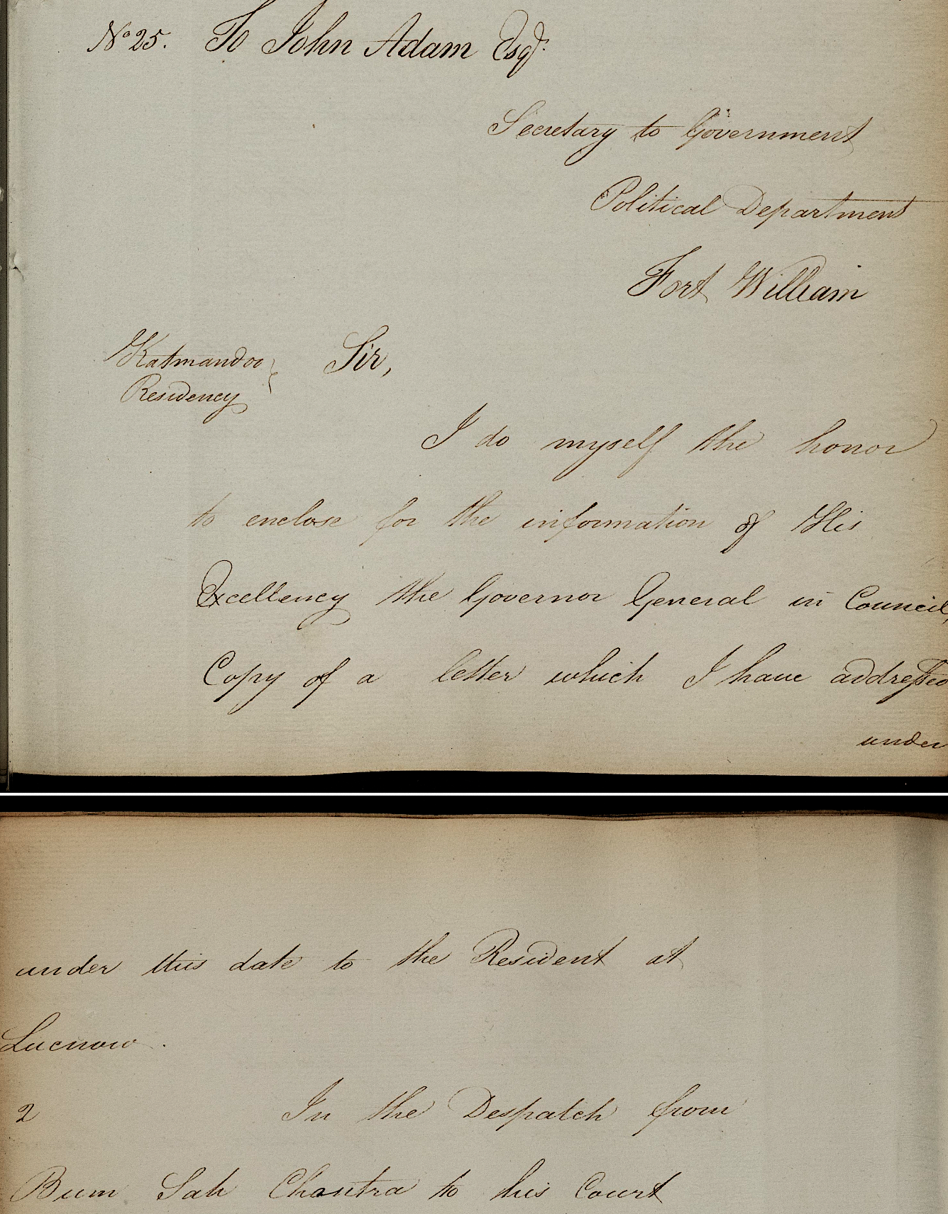
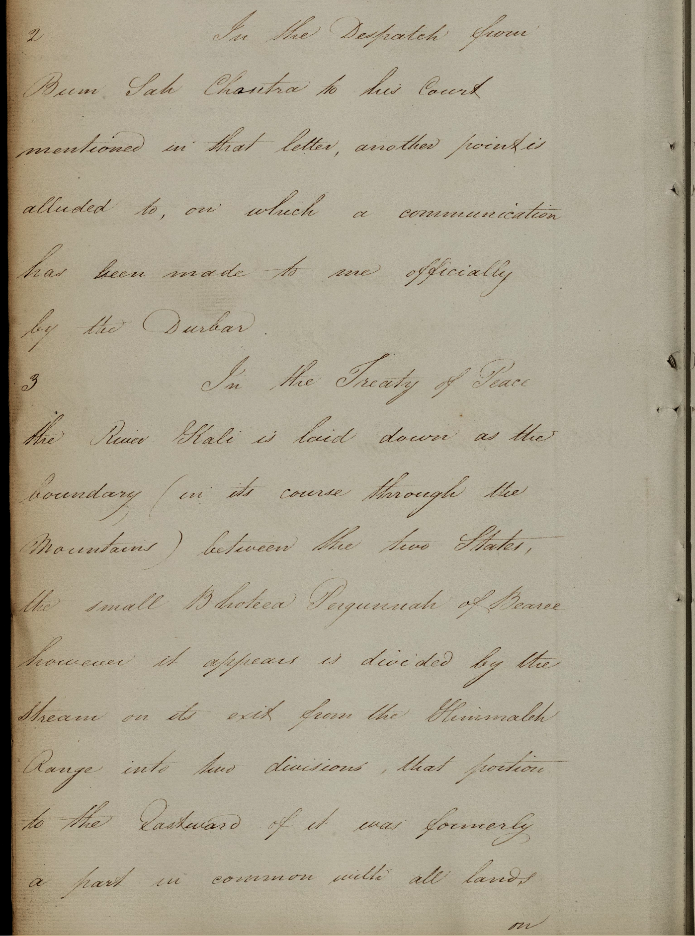
A full transcription of the letter:
From Resident at Cathmandu
Nepaul 12 January 1817
To John Adam Esq, Secretary to Government, Political Department, Fort William
I do myself the honor to enclose for the information of His Excellency, the Governor General in Council, Copy of a letter which I have addressed under this date to the Resident at Lucnow.
In the Despatch from Bum Sah Chautra to his Court mentioned in that letter, another point is alluded to, on which a communication has been made to me officially from the Durbar.
In the Treaty of Peace the River Kali is laid down as the boundary (in its course through the Mountains) between the two States, the small Bhotea Pergunnah of Beance however it appears is divided by the stream on its exit from the Himmaleh range into two divisions, that portion to the Eastward of it was formerly a part, in common with all lands on that side of the river, of the Province of Dotee but when Bum Sah held the Government of that and the adjacent Province of Kumaoon the Revenues of the Pergunnah were paid into the Treasury at Almorah and it was considered as annexed altogether to that Province. It fell with that Country into our possession at the late conquered and continued when I left it as an appendage of it as usual.
Bum Sah according to the letter of the Treaty, however, now asserts the claim of his Government to the villages situated to the Eastward or Dotee side of Kali, and as there is no doubt I believe that the Pergunnah in question is fairly divided by it, the pretension may be considered as just, this case forming no exception to the general line of demarcation settled by the terms of the Treaty.
I admitted to the Ministers the correctness of the Statement made by the Chautra Bum Sah as to the relative situation of that distant Pergunnah, but informed him that it was necessary before taking any steps in this affair that I should submit the question for the consideration of the Governor General in Council and take His Excellency’s Orders on the subject. I have to solicit therefore the instructions of His Lordship in Council on the subject.
I have the honor to…
Edward Gardner
Resident
Source: IOR/F/4/686/1, pp 341-345.
This next letter from Gardner to Strachey was attached to his letter to John Adam. (Though Gardner was charged with the responsibility of masterminding the handing over to Nepal this large stretch of Tarai land, he clearly regarded the Resident at Lucknow as his local man-on-the-spot who had to be kept informed of wider developments.)
Note that “the Treaty” mentioned in the third line is not the Sugauli Treaty. With the exception of three letters towards the end, this whole file (Vol 686) is dominated by references to another Treaty which is explained in the covering page of the file.
To Richard Strachey Esq
Resident at Lucknow
Sir,
A dispatch has been received by this Court from Bum Sah Chautra which has been communicated to me verbally reporting the progress of the delivery of the ceded territory to the west of the Rapti according to the terms of the Treaty, a reference however has been made by him respecting a spot, the name of which he has omitted to mention but which is said to be near the left bank of the Gogra, close to the mountains on which Ballas Gurhee is situated. This place it seems is occupied by a Chokee (a guard or watchman) established for the purpose of collecting the transit duties of merchandise passing from Dotee to Hindoostan and is peculiarly suited for such a purpose, and as it is considered as attached to the hills and is represented as of no other value being in the forest and waste and uninhabited, Bum Sah is desirous of it being left within the frontier of this state. He observes in his letter that he had strictly forbidden his people from opposing the officers of the Nawad Bezier who had consequently taken possession of it from them but requested his Court would communicate with me on the subject and endeavour to effect a settlement so as to leave it as an appendage to Dotee.
In replying to the representations made to me on the subject I informed the Minister that I was not sufficiently acquainted with the particulars of the case to offer any decided opinion as to the practicability of complying with their wishes, but at their solicitations I consented to bring the question to your notice and request that you would after enquiry endeavour to compromise this matter to the satisfaction of both governments.
I beg permission therefore to request that you will afford such attention to this point as you may consider yourself at liberty to give to it.
I have the honor to be, Sir,
Edward Gardner
Resident
IOR/F/4/686(1)/18894 pp. 345-348
What is said in these two letters should remove all doubt that the Kali river mentioned in the Treaty is the one which runs south from the area below Lipu Lekh and that Gorkha recognised and accepted this. As we have seen earlier, Bam Sah was personally very well-acquainted with this fact from his earlier experiences.
To better understand the context, here is a full transcription of John Adam’s letter dated 4 Feb 1817 which was prompted by Gardner’s letter to him dated 12 Jan 1817 and which had attached to it Gardner’s letter of the same date to Richard Strachey:
To the Resident at Catmandoo, the Honourable Edward Gardner Esq
Sir,
I am directed to acknowledge the receipt of your dispatch of the 12th Ultimo enclosing a Copy of your letter to the Resident at Lucknow respecting a spot on the left bank of the Gogra which Chautra Bum Sah is anxious should be left within the Nipaul Frontier, and reporting for the consideration and orders of Government a claim preferred by the Chautra to that portion of the Pergunnah of Beanse which lies East of the Kali and which is at present in the occupation of the British government as an appendage of the Province of Kumaon.
The tenor of your letter to the resident of Lucknow is entirely approved.
With respect to Bum Sahs [sic] claim to the tract on the Eastern side of the Kali, The Governor General in Council is of opinion that according to the Letter of the Treaty the Government of Nipaul is entitled to the restoration of it, notwithstanding its hither to having been regarded as annexed to the British province of Kumaoon. I am accordingly directed to intimate to you that the acting Commissioner for Kumaoon will be instructed to surrender it to the officers of the Nipaulese government. His Lordship in Council approves at the same time of the caution observed by you in declining to take any steps at the instance of the Nipaulese Minister in this affair until you had referred the question for the decision of your Government and should receive its orders.
Signed by John Adam
Acting Chief Sect to Govt.
4th Feb 1817
BL IOR/F/4/ 686-1, pp 348-350. (A copy of this letter is also available in Residency Records Nepal Letters from India 1816-1817 R/5/4 pp 209-211.)
In the file, under the original 4 Feb 1817 letter at Page 351, this note appears: “Ordered that a copy of the foregoing correspondence with Mr. Gardner be transmitted to Mr Traill for his information with a desire that he will be prepared to deliver over to the officers of the Nepalese Government on their application the tract of territory specified in Mr Gardner’s letter.”
Thus did Mr Traill first hear of what for him was the unwelcome order to hand over the two named villages. There is reference to a follow up letter, dated 18 Feb 1817, (see first line of his letter below to Adam, dated 8 March 1817) which clearly gave him further details. As this letter to Adam reveals, Traill strongly objected to the proposal and, as you will see, he felt he had good grounds for doing so:
From GW Traill, 8 March 1817
To J Adam Esquire
Secretary to Govt
Political Department
I have the honor to acknowledge the receipt of your dispatch of 18th February with its accompaniments relative to the Villages of Pergunnah Byans situated East of the River Kalee. The Principal Zemindars of that pergrunnah being in attendance, the orders of Government were communicated, a petition has in consequence been presented, translate of which I have the honor to transmit.
The Pergunnah in question contains eight villages assessed in the last year at R1915 of this number, two only, Tinkar and Changroo, are yielding a Jumma of 140 Rupees, are situated beyond the Kalee, the other six villages have however each a portion of land on that side. It may be here necessary to state that the Revenues of the Bhotee Pergunnah are derived entirely from the profits of trade. The productive land in the neighbourhood of the different villages yielding no more than sufficient for the support of the inhabitants. Should therefore the portions of land above alluded to be included in the proposed cession, a great part of the inhabitants will be reduced to the necessity of settling on the opposite side, and nearly the whole traffic of the Pergunnah will be transferred to.…[Three words were not decipherable, but R.S.Tolia’s transcription says, “The Doti marts in Nepal.”]) Under these circumstances I would beg leave to recommend the whole Pergannah be retained and the annual assessment of the claimed villages be paid to the Nepal government and from such an arrangement no confusion with regard to boundaries could ensue as the snowy mountains in which the Pergunnah of Byas is situated presents an insurmountable barrier. The neighbouring Gorkha Pergunnah of Jumlee there being communications I believe those two pergunnah except by proceeding northwards to the head of the Ghat through the Chinese territory southwards to the foot of the Ghat on the Kalee. The assessment of the two villages in question by the Gurkha government is as follows, Changroo105 and Tinkar 268 rupees giving a total of 373 Gurkha rupees or 280 Tubrukabad Rupees and the interest of the British Government would be commuted even should double that amount be paid. I take the opportunity of bringing to the notice of the Government the annual depredations committed on this province by the inhabitants of the Gorkha Pergunnah of the Joomlee.
Signed by G.W. Traill
8 March, 1817
Attached to the letter was this translation of a petition presented by the principal Zemindars of Pergunnah Byanse:
The orders of Government having been communicated to us we beg now to represent that from the Sambat year 1852 corresponding with the English year 1796 for a period of 22 years we have been annexed to the Province of Kumaoon and paid dues into the Kumaoon treasury in addition to which we pay tribute to the Chinese officer of Teklakot for the liberty of trading and are also subject to annual exactions by the Zamindars of Pergunnah Joomlee. We are now informed that the villages situated east of the Kalee are now to be attached to the Pergunnah of Dotee. There are only two villages so situated, Tinkar and Changroo. The remaining six villages of the Pergunnah, namely Boodhee, Gurbhuyan, Goonjee, Nabhee, Rokulee, Kuthee, however, derive the support of their inhabitants almost entirely from the produce of land situated on that side of the land is also to be included in the new arrangement by the Kalee being made the boundary, we shall be under the necessity of deserting the six villages in question and of transferring our trade to Dotee.
Six Zemindars of Pergannah Byans are listed and the translation is signed by G.W. Traill and addressed to J Adam. (Residency Records Nepal, Letters from India 1816-1817, R/5/4, pp. 271-275)
Just two weeks later, in this letter dated March 22, 1817, John Adam responded to Traill’s impassioned plea in a way which can most kindly be described as stern.
G.W. Traill Esq.
Acting Commissioner Kumaon
Dear Sir,
I am directed to acknowledge the receipt of your dispatch of 8th instant relative to the villages of Pergunnah Byans situated to the East of the Kali and enclosing a petition from the Booteea Zimeendars of that Pergunnah.
2. The letter and spirit of the Treaty of Peace give to the Nipaulese Government the undoubted right to all lands situated to the Eastward of the Kali whether heretofore forming part of the province of Kumaon or not and on the other hand it is extremely undesirable to manifest any reluctance to give prompt and full effect to those stipulations of the Treaty by which the extent of the remaining possessions of the Nipaulese is defined. There is little reason to suppose that the Nipaulese Government would consent to relinquish the land in question for a precursory payment and on the whole the Governor General in Council has determined to proceed at once to the restitution of the Nipaulese of the Villages and lands in question, which you will accordingly be prepared to make over to the officers of that Government on their application.
3. In reply to the petition of the Bhuteea Zemeendars, you will be pleased to explain to them the necessity of adhering to the conditions of the Treaty by which all lands situated Eastward of the Kali were secured to the Nipaulese and that the occupation of the villages and lands on that side of the river, having taken place under an erroneous view of the question, they must now be transferred to the Nipaulese, however desirous, the British government may be to retain under its own sway the Zimindars and inhabitants of those villages.
4. With regards to the annual depredations stated to be committed in the province of the Kumaon by the inhabitants of the Goorkali Pergunnah of Joomlee, I am directed to desire that you will report more particularly on that subject, in order that such representation as may be deemed proper, may be made to the Government of Nipaul with a view to prevent the renewal of those outrages
5. A copy of your letter of this dispatch will be transmitted to the Resident at Catmandhoo.
I have the honour to be,
John Adam
(acting Chief Secretary to the Government)
Fort William, 22 March, 1817
(Residency Records Nepal, Letters from India 1816-1817, R/5/4, pp. 277-279.)
As can be seen, Adam’s response is uncompromising. Nothing is conceded and Traill’s alternative proposal is dismissed out of hand. In short, Traill is ordered to get on with handing over Changru and Tinkar to Nepal, including, as we will see from a later letter, the rent which the Company had collected from the previous year.
Traill was very highly regarded. He had been personally chosen by Lord Moira to fill the Kumaon appointment after Gardner had departed for the Residency job in Kathmandu. So why did the senior figures in the EIC, so immediately and willingly, accede to Nepal’s claim and so dismissively reject the concerns of the Zemindars which were endorsed so strongly by one of the Company’s most respected and trusted officials?
I suggest, as a strong possibility, that, given the background of Nepal’s delay and initial reluctance to sign the agreed Treaty, Lord Moira and John Adam were delighted to receive a Nepalese claim to the two villages which so closely identified and accorded with the East India Company’s view on what the Treaty said about Nepal’s new western boundary. For them, callous as it might now seem, such an outcome more than outweighed any concerns they might have on the damage done to the life and livelihood of the Byansi community, at the time and subsequently.
On a less serious note, the phrase, having taken place under erroneous views of the question”, might have caught some eyes! I suggest that this might be an expression of frustration from John Adam that he had failed to foresee this claim from the Gorkha court emerging, even though Hearsey had alerted him to the fact that at least one of the Byanse villages was on the east side of the Kali.
I think that we can also safely assume that Traill took little notice of Adam’s advice on exactly how he should explain to the Zemindars the need to accede to Nepal’s claim!
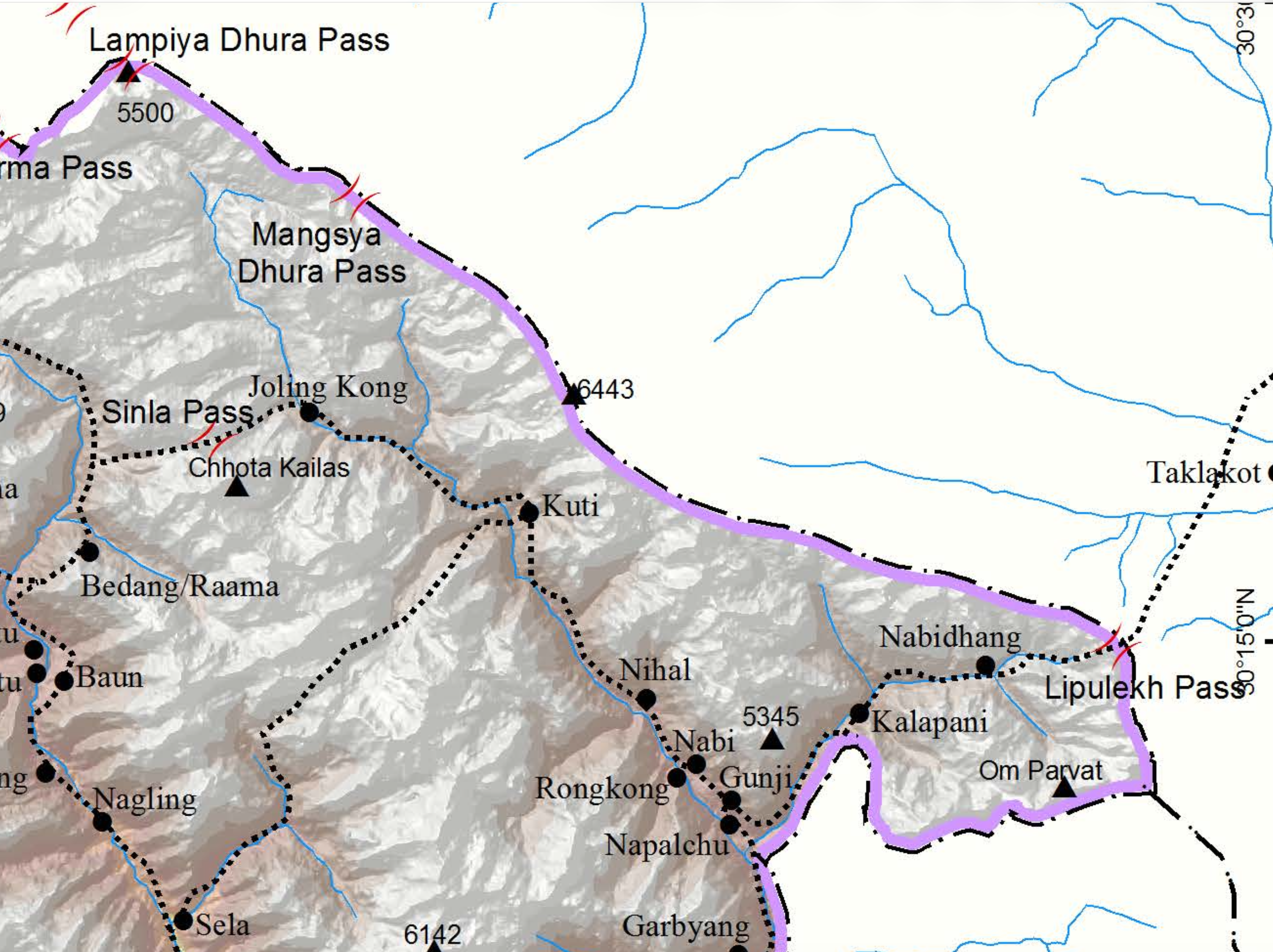
Later in 1817, Nepal made a second and very different claim which made no reference to the Treaty or what it said. To quote the words from Atkinson given earlier:
“But not satisfied with this advantage, the Nepalese claimed the villages of Kunti and Nabhi as also lying to the east of the Kali, averring that the Kunti Yankti or western branch of the head-waters should be considered the main stream as carrying the larger volume of water.”
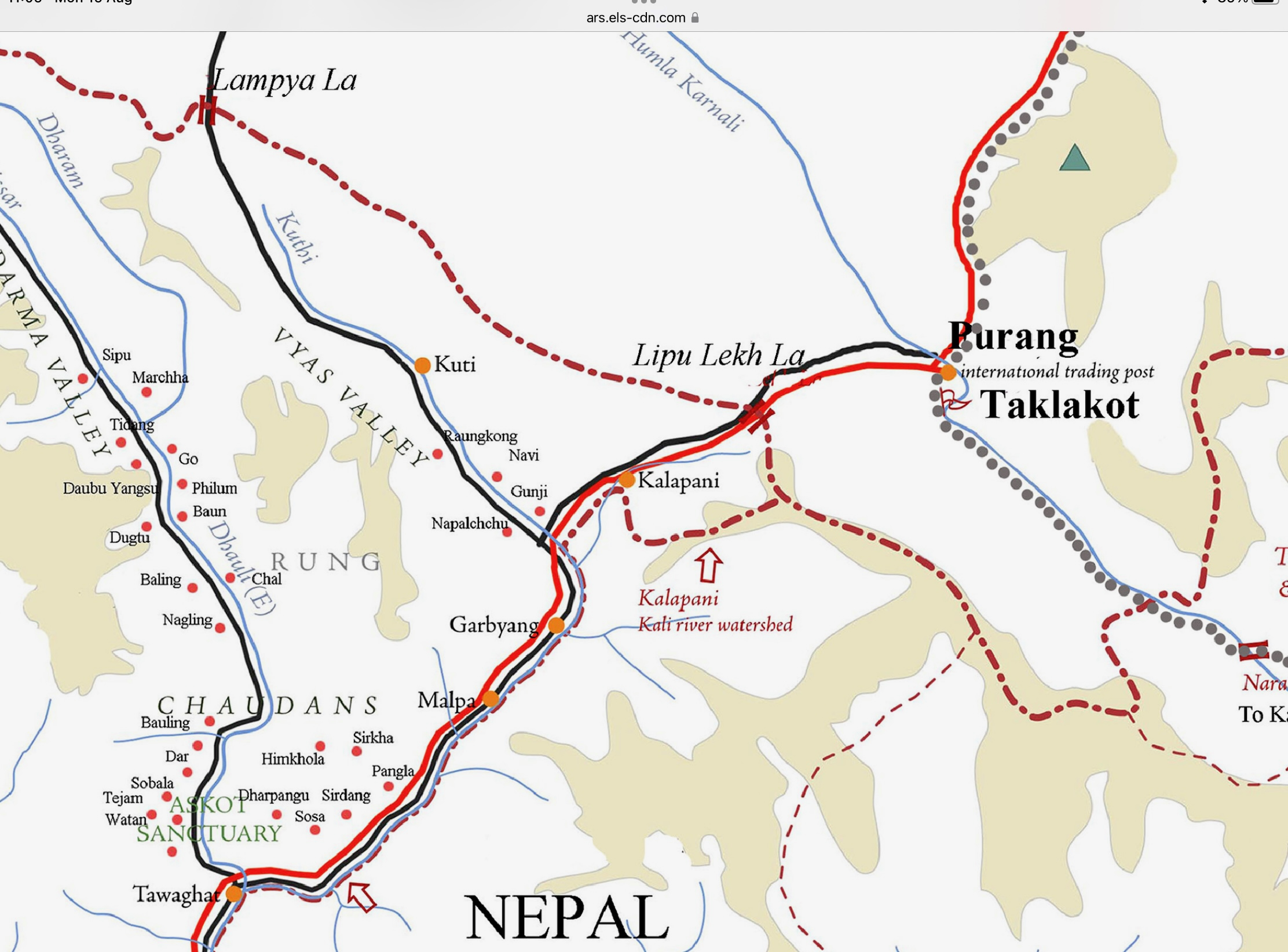
Looking at the map, the immediate question that springs to mind is, why is the basis of this second claim so different from the first one? Did the Government of Nepal get this idea from an established principle of hydrology or international law? The historical context argues strongly against such an explanation. In 1817, neither international law nor contemporary geographical science recognised any generally accepted principle that the principal sources of a boundary river is determined by the greatest volume of water. The scientific study of river systems was still in its infancy. So where did this new criterion come from? No contemporary evidence has yet come to light suggesting that this criterion reflected any established doctrine recognised by either government. Was it just a forlorn attempt to reopen the whole question? Once the East India Company conceded Tinkar and Changru, Nepal may have concluded that there was little to lose in calling for a much more extensive revision. It would be interesting to know if there is a surviving contemporaneous Nepali document that explicitly says that the western branch was the true Kali because it carried the greater volume of water? If one existed, I would have expected to see it quoted and referenced earlier and extensively in this debate though it would, of course, sit uneasily with the very different basis for the first claim made just a few months earlier.
Historically, rivers were named and their sources identified primarily through local geographical tradition, customer usage, religious association, and practical navigation rather than by any scientific measurement of discharge or length. For example, by the "greatest flow" or "furthest distance" standards, the Missouri River should be considered the main stem of the Mississippi River system. This illustrates that traditional naming conventions established centuries ago remain the standard today, illustrating that strict volumetric rules as a means of determining a river’s main branch were never universally applied or codified, and certainly not for a very long time after 1817.
There is contemporary evidence from 1816 that bears directly upon the question. My article, “Meetings on Lipu Lekh”, gives extended extracts from the diary of the surveyor, William Webb. It is pertinent to note that Webb was on the ground some nine months before this second claim was advanced. In early June 1816, he records that “no opportunity offered of instantly transmitting a statement of the above occurrences and since that period I have visited the source of the river Kalee and with imminent peril, crossed the Snowy Ridge separating Beeans from Dharma by the Pass of Lebong.”
Just a few days earlier he had recorded in his diary, “My tents were placed near the Fountain of Kalapani, a place of religious resort, and considered by the Natives as a source of the river of the same name.” Some 80 years later, Charles A. Sherring, passed close to the same spot and, in his book, The Sacred Country of Hindus and Buddhists, he recorded: “Then passing through the country of the Bhotias, viz., Chaudans and Byans, he (the pilgrim) is to worship at Kala Pani, the springs, which the devout Hindu considers the sources of the river Kali, and most sacred to the goddess of that name.” (p. 50)
As it turned out, this second claim was given a short shrift for the reasons given in the third paragraph of this letter from John Adam to G.W.Traill dated September 5, 1817:
I am directed to acknowledge the receipt of your dispatch of the 20 August with the several documents to be enclosed.
2. The Governor General entirely approves your having declined to transfer to Chautra Bum Sah the two villages of Koontee and Nabbee in Pegunnah Byanse without the specific orders of Government on the ground of their being situated to the west of the stream ordinarily recognised as the principal branch of the Kali in that quarter.
3. On examination of the maps transmitted by you and of the facts and circumstances detailed by yourself and Lieutenant Webb has left no doubt on the mind of the Governor General that the stream denominated Kala Panee is that which is to be considered as the principal branch of the Kali and as such it is to be held the boundary between the possessions of the two states as a question of equity and just construction of the Treaty therefore our retention of those two villages cannot be objected to. It appears on the other hand from your report and Lieutenant Webb’s, that considerable inconvenience would result from their surrender to the Nepalese Nepal on these considerations then, His Lordship has determined not to relinquish any portion of Pergunah Byanse lying to the Westward of the Kala Panee and you will accordingly be pleased to intimate this resolution together with the grounds of it to Chandra Bum Sah.
4. You are authorised to pay to Bum Sah Sonat Rupees 140.13 on account of the revenues of the villages of Tinkar and Chaunguroo.
6. A copy of this letter will be transmitted to the Resident at Kathmandu whom the Governor General concluded you have furnished with a copy of your dispatch and the enclosures if not, you will be pleased to do so without delay.
I have the Honor to be,
On the Ganges
Above Allahabad
John Adam, Secy to the Governor General
5th September 1817
(Bhasin, Vol IV, Section VI, Appendix IV, pp. 3034-3035.)
In this letter, Adam refers to the considerable inconvenience that would result from acceding to this Nepalese claim. I am certain that Lord Moira would have seen the major problems that would emerge in very much stronger terms. It is inconceivable that he could ever have even contemplated handing over to a defeated Gorkha exclusive rights of control of trade over the pass at Lipu Lekh, one of the great prizes for which EIC fought the war, and which, in many letters back to the EIC Directors in London over the previous six months, as the cost of the war kept exceeding all estimates, Moira had spoken of Lipu Lekh as a great prize that would yield much trade and profit. I have also found it very odd that while the earlier claim for Tinkar and Changru came from the Durbar in Kathmandu direct to Gardner, the British Resident, this second claim came direct from Bam Sah, at that time Governor of Doti, to G.W.Traill, the Commissioner of Kumaon. Hence my strong feeling that Bam Sah, above all, must have known that this second claim was a long shot that had no real chance of success. A further pointer in that direction is the absence of any evidence of any push-back from Nepal against the EIC’s speedy rejection of the claim.
This final shared letter is the penultimate one listed at the end of Atkinson’s summary referred to earlier. In it, Edward Gardner assures John Adam that if Nepal ever resurrected this claim in future, it would again be speedily rejected in the firmest terms:
Nepaul 10th October 1817
To John Adam Esquire
Secretary to the Governor General
I have the Honor to acknowledge the receipt of your dispatch under date 5th Ultimo with the enclosure addressed to Commissioner for Kumaon, on the subject of the Villages of Pergunnah Byanse situated to the Westward of the River Kalee.
2. I have since been furnished by Mr Traill with a copy of his Despatch to you of the 29th of August, enclosing a letter on this subject from Lieutenant Webb. A copy of Mr. Traill's letter forwarding these documents is enclosed for the information of His Excellency The Governor General
3. in the event of the admonistration (sic) here renewing the question respecting the Villages of Koontee and Nabhee I shall be prepared to communicate to them the substance of the enquiry which has been made regarding the principal branch of the Kalee, which is to be held the boundary between the possessions of the two States in that quarter, and of the decision of the British government on this case, and the resolution in consequence of His Excellency The Governor General not to relinquish any portion of Pergannah Byanse lying to the Westward of the Stream known by the name Kalee Panee.
I have the Honour to be, Sir,
(Signed) Edward Gardner, Resident Nepaul.
10 October 1817.
(Residency Records, Nepal Letters to India 1817 R/5/39 pp. 158-159)
First, when Lord Moira made the statements which I highlighted early in this article, he was drawing on a massive and intensive intelligence effort which drew on a range of high-quality sources who were solidly connected with reliable informants. The speculation on the possibility of gaining a monopoly over the ‘shawl-wool’ was to prove hopelessly illusory but on the solid facts of geography Moira and his team, from a very early stage, were remarkably sound and accurate and, most notably so, when it came to identifying the Kali river mentioned in the Treaty as the stream which flowed down from the area of Lipu Lekh. The basis of the claim that came from the Nepal Durbar in early 1817 for handing back the villages of Changru and Tinkar show beyond any doubt that Nepal shared the same view on the origin of the Kali mentioned in the Treaty.
The focus for this well-targeted and highly successful intelligence-gathering operation also included the northern areas of the occupied territories of Kumaon and Garhwal, and the routes which ran through them to the high passes which led into Tibet. This work enabled the Company to go firm at a strikingly early stage of the war on the most advantageous new frontier that needed to be imposed on Gorkha when the war ended. [See details in my earlier articles, and particularly in, “The battle for the ear of the Emperor”, on why there no chance of EIC Directors in London giving Lord Moira permission to attack the Gorkha homeland – in essence, the fear of losing the right to buy tea though Canton.] There were no such concerns about taking over the territories of Garhwal and Kumaon. Acquisition of these territories would deliver a long sought after prize for the EIC of bringing British territory into direct contact with that under the sovereignty of the Chinese emperor. (As an additional reference see, British India and Tibet: 1766-1910, Alastair Lamb, p. 43)
Secondly, in early January 1817, when Nepal launched a claim for the two villages of Tinkar and Changru, the argument advanced by the durbar to the British Resident in support of this claim showed very clearly that the Nepal government was fully aware, and accepted without reservation, that the reference in the Sugauli Treaty to the Kali as the boundary between the two states meant the river which flows down from the area of Lipu Lekh. This fact is indisputable. All arguments based around, “which was the Kali mentioned in the Treaty”, are irrelevant and misleading. We have a clear answer and clear evidence of agreement on the point at the time by both sides. We also have evidence that Bam Sah, the lead man for Gorkha in negotiations at the time, had particularly intimate knowledge of the terrain in the area just south of the Lipu Lekh pass. In short, more than any Gorkha around at the time, Bam Sah knew well what the Surveyor William Webb found when he visited the area in June 1816, and reported that his, “tents were placed near the Fountain of Kalapani, a place of religious resort, and considered by the Natives as a source of the river of the same name.”
Several months later, Nepal put forward a second claim which had a very short shelf life, a few months at most. The claim made no reference to the Treaty. Instead, it simply asserted that the international boundary should follow the line of the river which flows down from Limpiyadhura as it carried the stronger stream of water. It is worth noting that this claim came not from the Durbar through the Resident in Kathmandu but direct from Bam Sah as Governor of Dotee to GW Traill, the senior EIC official in Kumaon. The claim was dismissed in emphatic terms by the Governor General, Lord Moira, in a letter dated September 5, 1817, and nothing more was heard of it until June 2020. It is hardly a surprise that Gorkha, through Bam Sah, did not press the point. With his intimate knowledge of the area and of the value and importance of the trade which passed through it over the pass of Lipu Lekh, Bam Sah, above all, would have known that there was no chance of the EIC agreeing to a claim which would have given Gorkha exclusive control over Lipu Lekh and the trade which passed over it; one of the prime aims of the war.
Since no map was attached to the Treaty to show the line of the Kali mentioned in it, and which would meet the Governor General’s two main objectives, our only reliable guides are what was written at the time and how, by their actions, the belligerents, particularly the victor, interpreted the written words, again at the time. Nothing that happened later, or did not happen, is pertinent to that determination and that includes multiple maps produced for commercial gain or any other maps which did not bear the official imprimatur of the Survey Department of the Survey of India. The first relevant one to do so did not appear until 1850. This was the “Map of Kumaon and British Gurhwal”, published in 1850, which accurately showed the line of the border as decreed in the Sugauli Treaty and as defined by the words of the Governor General, quoted in the letter dated September 5, 1817, which rejected in the strongest terms Nepal’s claim to the land it is now claiming again, using the same rejected argument. Notably, as an example of Nepal’s long consistency on the subject, it also perfectly aligns with the words and argument advanced by Nepal in January 1817 when it claimed control of the villages of Tinkar and Changru.
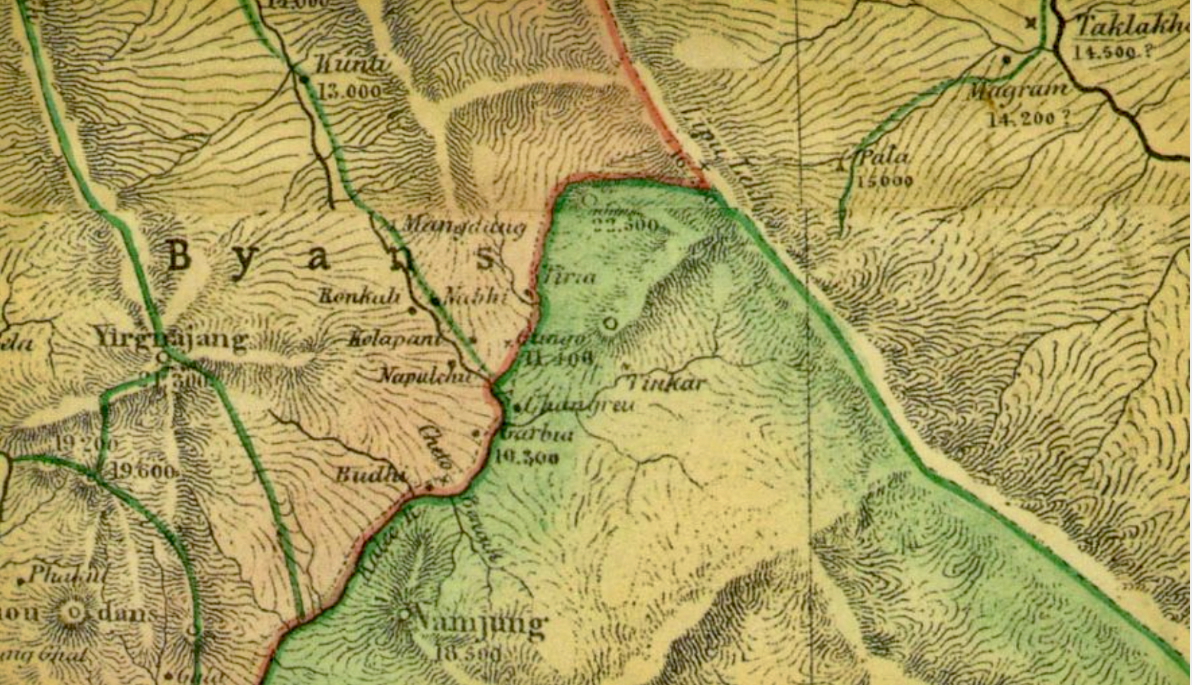
This 1850 map also accords perfectly with the detail in the succinct, eloquent, and historically correct letter which Girija Prasad Koirala, then Prime Minister of Nepal, wrote to the Delegated Legislation and Government Assurances Committee of the National Assembly regarding the Mahakali-Kali river Boundary between India and Nepal, dated June 18, 1998:
“According to the Treaty of Sugauli signed in 1816 with the British India, the Kali river was established as the western boundary of Nepal. According to a map prepared by the Survey of India in 1850, the Kali river, which has its source at the Lipu Lekh pass, was shown as the boundary. In another map published by the Survey of India in 1856, the Kali river was shown as the boundary between the two countries as was already shown in the map of 1850. According to the above-mentioned maps, Kalapani comes under the territory of Nepal.
Subsequently, the Survey of India published a map in 1879 in which the boundary was shifted from the Kali river to the ridge [watershed] on the southern side of the Pankhagad river beyond Kalapani. In this map, Kalapani has been shown on the Indian side.
When Nepal and China signed boundary agreements in 1961 and 1979, Lipu Lekh Pass was treated as the origin of the Kali river as per the 1850 map of the Survey of India in order to determine the trijunction point.
There is no justification or basis now for claiming Kalapani as a part of India as the maps published in 1850 and 1856 by the Survey of India show the Kali river originating from the Lipu Lekh pass as the boundary between the two countries. Kalapani is Nepalese territory. In the maps recently published by the Survey of Nepal, the boundary between the two countries have been shown along the Kali river originating from the Lipu Lekh pass and Kalapani has been shown as a part of the Nepalese territory.
In view of the presence of Indian-Tibetan Border police post in the Kalapani area, and Indian claim on this area, the two countries are holding bilateral talks to prove their respective claims supported by evidence.”
(Bhasin, Vol IV, Section VI, Doc 1204, p. 2948)
(I have dealt at length with the 1879 map in Part 4 of my article, “The Gorkha War and its aftermath,” which is significantly headed as, “A missed opportunity to right an historical wrong.”)
PERSONAL
This is the opening paragraph from my article, “The Gorkha War and its aftermath,” published on Nov 14, 2020: “On June 11, 2020, Nepal’s prime minister, Mr KP Oli, while addressing the House of Representatives, claimed that, ‘It was only after India stationed its troops in Kalapani that we could not go to Kalapani, Limpiyadhura, or Lipulekh’. He added that his government would reclaim these areas on the basis of evidence and historical facts. [See Himalayan Times article, dated June 11, 2020, “PM Oli stirs nationalist sentiments to hide govt failure”.] For context, here is the opening paragraph from the Himalayan Times article:
“At a time when the government is being criticised for its failure to check the spread of the coronavirus and not using the lockdown period to prepare itself for the rising number of COVID-19 patients, Prime Minister KP Sharma Oli today tried to deflect attention from his government’s shortcomings by stirring up nationalist sentiment.”)
Back to my text:
On June 13, 2020, the House of Representatives unanimously endorsed the constitution amendment bill to pave the way for replacing Nepal’s map in the national emblem with the country’s new political and administrative map that includes Kalapani, Lipu Lekh, and Limpiyadhura. Almost immediately, the official spokesperson of the Indian Ministry of External Affairs (MEA) was widely quoted as saying: “The artificial enlargement of claims is not based on historical fact or evidence and is not tenable”
(I was wrong on “unanimous endorsement”. There was one lady, Sarita Giri, who sought to register an amendment aimed mainly, I think, at giving people more time to consider the political implications, and particularly the international impact, of what was proposed. Her attempt failed.)
I concluded the introduction by writing: “Both PM Oli and the spokesman for India’s MEA claimed that the historical facts were on their side. This article is my attempt to contribute to an understanding of them.”
That effort continues with this and all my articles.
What I have highlighted is still India’s position. From my reading of the Kathmandu media, and many social media posts, Nepal’s belief in the overriding strength of its claim grows ever stronger, as does its belief in the lack of any merit in India’s claim. Thus, we have an insoluble problem with the creation of permanent friction between the two countries. Those who resurrected a 200-year-old claim, using the same rejected argument, and which was quickly dropped and forgotten at the time, must surely have expected such an outcome and were happy to live with it?
My own position should be very clear. I stand by what I wrote earlier: Since no map was attached to the Treaty to show the line of the Kali mentioned in it, and which would meet the Governor General’s two objectives, our only reliable guides are what was written at the time and how, by their actions, the belligerents, particularly the victor, interpreted the written words, again at the time. Nothing that happened later, or did not happen, is pertinent to that determination.
We are fortunate that in the national archives of India and Britain, there is no shortage of what was written in 1817 to help us judge exactly what was said and agreed at the time between Nepal and the East India Company on the line of the Kali referred to in the Treaty and hence on the line of the new frontier. This should be abundantly clear from the letters, all written in 1817, which I have shared with readers in this article. Absolute confirmation of what was agreed in 1817 was shown in the 1850 map and I cannot do better than repeat the words of BP Koirala, dated June 18, 1998, which I have already quoted: “According to the Treaty of Sugauli signed in 1816 with the British India, the Kali river was established as the western boundary of Nepal. According to a map prepared by the Survey of India in 1850, the Kali river, which has its source at the Lipu Lekh pass, was shown as the boundary.”
I finish with the good news that it is now possible to access a very wide range of East India Company files without having to visit the British Library or the Indian National Archives. The not-so-good news is that access is generally granted via institutional subscriptions from a university or library. For advice and further details, visit:
https://www.eastindiacompany.amdigital.co.uk
The Bodleian Library is a subscriber and as a card holder I have been able to gain access to the site by using a computer in the Bodleian. (University card holders can get remote access.) I found the site difficult to interrogate but I must pay tribute to Emma Mathieson who works in the Bodleian and who used the site to unearth the two seminal documents I refer to in my article. They were in a file which I would never normally have thought of as having any connection with the subject I was researching. Perhaps some benefactor or educational institution in Nepal can be found to make East India Company, to give it its trade name, available in Nepal!
I feel I can now reasonably withdraw from this debate. In this article, with the unearthing of the two seminal letters, I have been able to tell the whole story by printing in full all the key letters and allowing people to read them and to make up their own minds. No selective quoting, no passing over awkward truths and, most importantly, no conflating of the two separate claims. It is worth stressing that, at the time, these claims were not the subject of long, drawn-out debate. The first claim emerged in early January 1817 and all matters relating to it and the subsequent one were settled definitively by September 1817. Letters and speculation outside this period are irrelevant. I end the article, as I have ended all my previous articles on the subject, by stressing that Kalapani is a different issue, as is Nepal’s case for shared access to Lipu Lekh.

Sam Cowan Sam Cowan is a retired British general who knows Nepal well through his British Gurkha connections and extensive trekking in the country over many years.


Interviews
7 min read
Part 2 of our series on Naraynhiti Palace Museum and it's significance.

Perspectives
6 min read
Legal hurdles have prevented the #MeToo movement from taking off in Nepal

Features
5 min read
Explosives used during Nepal’s armed conflict continue to take lives

Podcast
History Series
1 min read
Gorkhalis put up a tough fight but a change in British strategy brings about a decisive turn of events

Longreads
Features
Popular
23 min read
Boudha once had a long and rich relationship with water but with the explosion of concrete houses and paved roads, fresh water is becoming more and more scarce.